Arsiero geodata
Arsiero (Veneto) is a seat of a third-order administrative division; located in Italy in Europe/Rome (GMT+2) time zone. With population of 2,720 people, there are 3291 cities with bigger population in this country. Compared to other cities in Italy, 85.9% of cities are located further ↓South; 52.5% of cities are located further →East and 61.9% of cities have lower elevation than Arsiero. Note1


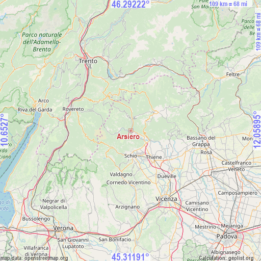
Arsiero GPS coordinates[2]
45° 48' 15.192" North, 11° 21' 20.952" East
| Map corner | latitude | longitude |
|---|---|---|
| Upper-left | 46.29222°, | 10.6527° |
| Center: | 45.80422°, | 11.35582° |
| Lower-right: | 45.31191°, | 12.05895° |
| Map W x H: | 109×109 km | = 67.7×67.7mi |
| max Lat: | 47.04031° ⇑14.1% North |
| Arsiero: | 45.80422° |
| min Lat: | ⇓85.9% South 35.50142° |
| min Long | Arsiero | max Long |
| 6.69888° | 11.35582° | 18.48682° |
| W 47.5%⇐ | ⇒52.5% E |
Elevation
Elevation of Arsiero is 314 m = 1030 ft, and this is 7.3 m = 24 ft above average elevation for this country.
| Max E: |
2085 m = 6841 ft | 38.1% |
| Arsiero | 314 m 1030 ft | |
| Avg. | 306.7 m = 1006 ft | |
Min E: |
-4 m = -13 ft | 61.9% |
See also: Italy elevation on elevation.city.
Geographical zone
Arsiero is located in North temperate zone (between Tropic of Cancer and the Arctic Circle). Distance of this North polar circle is 2308.2 km =1434.2 mi to North.| Distance of | km | miles | from Arsiero |
|---|---|---|---|
| North Pole | 4914.1 | 3053.5 | to North |
| Arctic Circle | 2308.2 | 1434.2 | to North |
| Tropic Cancer | 2487 | 1545.3 | to South |
| Equator | 5093 | 3164.6 | to South |


Nearby cities:
15 places around Arsiero: (largest is in red/bold)
• Caltrano
8.5 km =5.3 mi,  113°
113°
• Cesuna
8.6 km =5.3 mi,  64°
64°
• Chiuppano
9.1 km =5.7 mi,  120°
120°
• Cogollo del Cengio
5.8 km =3.6 mi, 112°
• Laghi
6.8 km =4.2 mi,  289°
289°
• Piovene Rocchette
8 km =5 mi,  131°
131°
• Posina
7.4 km =4.6 mi,  258°
258°
• Rotzo
7.1 km =4.4 mi,  25°
25°
• San Pietro Valdastico
9.2 km =5.7 mi,  2°
2°
• Santorso
8.2 km =5.1 mi,  162°
162°
• Seghe
1.4 km =0.9 mi, 113°
• Tonezza del Cimone
6.1 km =3.8 mi,  352°
352°
• Treschè Conca
6.8 km =4.2 mi, 55°
• Velo
1.8 km =1.1 mi,  151°
151°
• Velo d'Astico
2 km =1.2 mi, 152°
Sources, notices
• [Note1] Compared only with cities in Italy existing in our database
• [Src1] Map data: © OpenStreetMap contributors (CC-BY-SA)
• [Src2] Other city data from geonames.org with taken over terms of usage.
• [Src3] Geographical zone / Annual Mean Temperature by Robert A. Rohde @ Wikipedia
