Crecchio geodata
Crecchio (Abruzzo) is a seat of a third-order administrative division; located in Italy in Europe/Rome (GMT+2) time zone. With population of 523 people, there are 9703 cities with bigger population in this country. Compared to other cities in Italy, 67.7% of cities are located further ↑North; 81.1% of cities are located further ←West and 54.6% of cities have higher elevation than Crecchio. Note1


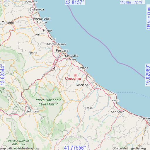
Crecchio GPS coordinates[2]
42° 17' 52.008" North, 14° 19' 35.616" East
| Map corner | latitude | longitude |
|---|---|---|
| Upper-left | 42.8157°, | 13.62344° |
| Center: | 42.29778°, | 14.32656° |
| Lower-right: | 41.77556°, | 15.02969° |
| Map W x H: | 115.7×115.7 km | = 71.9×71.9mi |
| max Lat: | 47.04031° ⇑67.7% North |
| Crecchio: | 42.29778° |
| min Lat: | ⇓32.3% South 35.50142° |
| min Long | Crecchio | max Long |
| 6.69888° | 14.32656° | 18.48682° |
| W 81.1%⇐ | ⇒18.9% E |
Elevation
Elevation of Crecchio is 205 m = 673 ft, and this is 101.7 m = 334 ft below average elevation for this country.
| Max E: |
2085 m = 6841 ft | 54.6% |
| Avg. | 306.7 m = 1006 ft | |
| Crecchio | 205 m = 673 ft | |
Min E: |
-4 m = -13 ft | 45.4% |
See also: Italy elevation on elevation.city.
Geographical zone
Crecchio is located in North temperate zone (between Tropic of Cancer and the Arctic Circle). Distance of this Northern Tropic circle is 2097.2 km =1303.1 mi to South.| Distance of | km | miles | from Crecchio |
|---|---|---|---|
| North Pole | 5304 | 3295.8 | to North |
| Arctic Circle | 2698.1 | 1676.5 | to North |
| Tropic Cancer | 2097.2 | 1303.1 | to South |
| Equator | 4703.1 | 2922.4 | to South |


Nearby cities:
15 places around Crecchio: (largest is in red/bold)
• Ari
5.7 km =3.5 mi,  260°
260°
• Arielli
4.4 km =2.7 mi,  197°
197°
• Canosa Sannita
1.8 km =1.1 mi, 264°
• Frisa
5.4 km =3.4 mi,  131°
131°
• Giuliano Teatino
4.1 km =2.5 mi,  293°
293°
• Miglianico
7.3 km =4.5 mi,  336°
336°
• Poggiofiorito
4.9 km =3 mi,  185°
185°
• Sant'Amato-Nasuti
7 km =4.3 mi,  159°
159°
• Sant'Apollinare
6.8 km =4.2 mi,  91°
91°
• Santa Lucia
7.4 km =4.6 mi,  59°
59°
• Tollo
5.3 km =3.3 mi,  357°
357°
• Vacri
8 km =5 mi,  269°
269°
• Villa Caldari
2.9 km =1.8 mi, 94°
• Villa Grande
4.6 km =2.9 mi,  41°
41°
• Villa San Leonardo
6.2 km =3.9 mi,  76°
76°
Sources, notices
• [Note1] Compared only with cities in Italy existing in our database
• [Src1] Map data: © OpenStreetMap contributors (CC-BY-SA)
• [Src2] Other city data from geonames.org with taken over terms of usage.
• [Src3] Geographical zone / Annual Mean Temperature by Robert A. Rohde @ Wikipedia
