Tollo geodata
Tollo (Abruzzo) is a seat of a third-order administrative division; located in Italy in Europe/Rome (GMT+2) time zone. With population of 3,093 people, there are 2967 cities with bigger population in this country. Compared to other cities in Italy, 67.3% of cities are located further ↑North; 81.1% of cities are located further ←West and 61.2% of cities have higher elevation than Tollo. Note1


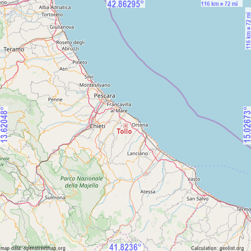
Tollo GPS coordinates[2]
42° 20' 43.512" North, 14° 19' 24.96" East
| Map corner | latitude | longitude |
|---|---|---|
| Upper-left | 42.86295°, | 13.62048° |
| Center: | 42.34542°, | 14.3236° |
| Lower-right: | 41.8236°, | 15.02673° |
| Map W x H: | 115.6×115.6 km | = 71.8×71.8mi |
| max Lat: | 47.04031° ⇑67.3% North |
| Tollo: | 42.34542° |
| min Lat: | ⇓32.7% South 35.50142° |
| min Long | Tollo | max Long |
| 6.69888° | 14.3236° | 18.48682° |
| W 81.1%⇐ | ⇒18.9% E |
Elevation
Elevation of Tollo is 154 m = 505 ft, and this is 152.7 m = 501 ft below average elevation for this country.
| Max E: |
2085 m = 6841 ft | 61.2% |
| Avg. | 306.7 m = 1006 ft | |
| Tollo | 154 m = 505 ft | |
Min E: |
-4 m = -13 ft | 38.8% |
See also: Italy elevation on elevation.city.
Geographical zone
Tollo is located in North temperate zone (between Tropic of Cancer and the Arctic Circle). Distance of this Northern Tropic circle is 2102.5 km =1306.4 mi to South.| Distance of | km | miles | from Tollo |
|---|---|---|---|
| North Pole | 5298.7 | 3292.5 | to North |
| Arctic Circle | 2692.8 | 1673.2 | to North |
| Tropic Cancer | 2102.5 | 1306.4 | to South |
| Equator | 4708.4 | 2925.7 | to South |


Nearby cities:
15 places around Tollo: (largest is in red/bold)
• Ari
8.2 km =5.1 mi,  220°
220°
• Canosa Sannita
5.7 km =3.5 mi,  195°
195°
• Castelferrato
9.1 km =5.7 mi,  292°
292°
• Crecchio
5.3 km =3.3 mi,  177°
177°
• Francavilla al Mare
9.1 km =5.7 mi,  338°
338°
• Giuliano Teatino
5.1 km =3.2 mi, 223°
• Miglianico
3 km =1.9 mi,  297°
297°
• Ortona
6.6 km =4.1 mi,  84°
84°
• Ripa Teatina
6.9 km =4.3 mi, 289°
• Sant'Apollinare
8.9 km =5.5 mi,  127°
127°
• Santa Lucia
6.8 km =4.2 mi,  102°
102°
• Villa Caldari
6.4 km =4 mi,  150°
150°
• Villa Grande
3.8 km =2.4 mi,  119°
119°
• Villa San Leonardo
7.4 km =4.6 mi, 121°
• Villamagna
7.3 km =4.5 mi,  256°
256°
Sources, notices
• [Note1] Compared only with cities in Italy existing in our database
• [Src1] Map data: © OpenStreetMap contributors (CC-BY-SA)
• [Src2] Other city data from geonames.org with taken over terms of usage.
• [Src3] Geographical zone / Annual Mean Temperature by Robert A. Rohde @ Wikipedia
