Arcore geodata
Arcore (Lombardy) is a seat of a third-order administrative division; located in Italy in Europe/Rome (GMT+2) time zone. With population of 16,690 people, there are 537 cities with bigger population in this country. Compared to other cities in Italy, 78.1% of cities are located further ↓South; 75.9% of cities are located further →East and 56% of cities have higher elevation than Arcore. Note1
Administrative division(s):
- Level 1: Lombardy
- Level 2: Provincia di Monza e della Brianza
- Level 3: Arcore


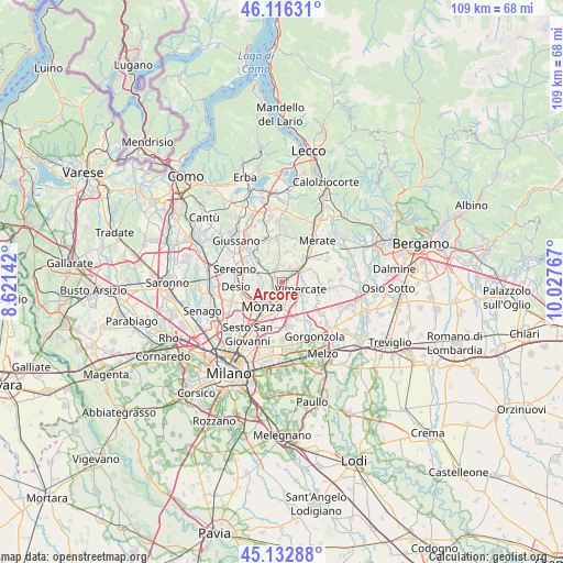
Arcore GPS coordinates[2]
45° 37' 36.3" North, 9° 19' 28.344" East
| Map corner | latitude | longitude |
|---|---|---|
| Upper-left | 46.11631°, | 8.62142° |
| Center: | 45.62675°, | 9.32454° |
| Lower-right: | 45.13288°, | 10.02767° |
| Map W x H: | 109.3×109.3 km | = 67.9×67.9mi |
| max Lat: | 47.04031° ⇑21.9% North |
| Arcore: | 45.62675° |
| min Lat: | ⇓78.1% South 35.50142° |
| min Long | Arcore | max Long |
| 6.69888° | 9.32454° | 18.48682° |
| W 24.1%⇐ | ⇒75.9% E |
Elevation
Elevation of Arcore is 195 m = 640 ft, and this is 111.7 m = 366 ft below average elevation for this country.
| Max E: |
2085 m = 6841 ft | 56% |
| Avg. | 306.7 m = 1006 ft | |
| Arcore | 195 m = 640 ft | |
Min E: |
-4 m = -13 ft | 44% |
See also: Italy elevation on elevation.city.
Geographical zone
Arcore is located in North temperate zone (between Tropic of Cancer and the Arctic Circle). Distance of this North polar circle is 2328 km =1446.6 mi to North.| Distance of | km | miles | from Arcore |
|---|---|---|---|
| North Pole | 4933.8 | 3065.7 | to North |
| Arctic Circle | 2328 | 1446.6 | to North |
| Tropic Cancer | 2467.3 | 1533.1 | to South |
| Equator | 5073.2 | 3152.3 | to South |


Nearby cities:
15 places around Arcore: (largest is in red/bold)
• Biassono
4.1 km =2.5 mi,  272°
272°
• Camparada
3.1 km =1.9 mi,  358°
358°
• Campofiorenzo-California
4.6 km =2.9 mi,  352°
352°
• Canonica
4.3 km =2.7 mi,  318°
318°
• Carnate
4.8 km =3 mi,  59°
59°
• Concorezzo
4.3 km =2.7 mi,  170°
170°
• Correzzana
4.6 km =2.9 mi,  343°
343°
• Lesmo
2.8 km =1.7 mi,  331°
331°
• Macherio
4.2 km =2.6 mi,  290°
290°
• Sovico
5.3 km =3.3 mi, 293°
• Usmate-Velate
3.8 km =2.4 mi,  51°
51°
• Vedano al Lambro
4.8 km =3 mi,  245°
245°
• Velasca
2.4 km =1.5 mi,  77°
77°
• Villasanta
2.6 km =1.6 mi,  209°
209°
• Vimercate
3.6 km =2.2 mi,  110°
110°
Sources, notices
• [Note1] Compared only with cities in Italy existing in our database
• [Src1] Map data: © OpenStreetMap contributors (CC-BY-SA)
• [Src2] Other city data from geonames.org with taken over terms of usage.
• [Src3] Geographical zone / Annual Mean Temperature by Robert A. Rohde @ Wikipedia
