Sovico geodata
Sovico (Lombardy) is a seat of a third-order administrative division; located in Italy in Europe/Rome (GMT+2) time zone. With population of 7,624 people, there are 1280 cities with bigger population in this country. Compared to other cities in Italy, 78.9% of cities are located further ↓South; 77.1% of cities are located further →East and 52.2% of cities have higher elevation than Sovico. Note1
Administrative division(s):
- Level 1: Lombardy
- Level 2: Provincia di Monza e della Brianza
- Level 3: Sovico


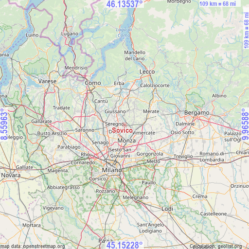
Sovico GPS coordinates[2]
45° 38' 45.528" North, 9° 15' 45.9" East
| Map corner | latitude | longitude |
|---|---|---|
| Upper-left | 46.13537°, | 8.55963° |
| Center: | 45.64598°, | 9.26275° |
| Lower-right: | 45.15228°, | 9.96588° |
| Map W x H: | 109.3×109.3 km | = 67.9×67.9mi |
| max Lat: | 47.04031° ⇑21.1% North |
| Sovico: | 45.64598° |
| min Lat: | ⇓78.9% South 35.50142° |
| min Long | Sovico | max Long |
| 6.69888° | 9.26275° | 18.48682° |
| W 22.9%⇐ | ⇒77.1% E |
Elevation
Elevation of Sovico is 221 m = 725 ft, and this is 85.7 m = 281 ft below average elevation for this country.
| Max E: |
2085 m = 6841 ft | 52.2% |
| Avg. | 306.7 m = 1006 ft | |
| Sovico | 221 m = 725 ft | |
Min E: |
-4 m = -13 ft | 47.8% |
See also: Italy elevation on elevation.city.
Geographical zone
Sovico is located in North temperate zone (between Tropic of Cancer and the Arctic Circle). Distance of this North polar circle is 2325.8 km =1445.2 mi to North.| Distance of | km | miles | from Sovico |
|---|---|---|---|
| North Pole | 4931.7 | 3064.4 | to North |
| Arctic Circle | 2325.8 | 1445.2 | to North |
| Tropic Cancer | 2469.4 | 1534.4 | to South |
| Equator | 5075.4 | 3153.7 | to South |


Nearby cities:
15 places around Sovico: (largest is in red/bold)
• Albiate
1.4 km =0.9 mi,  317°
317°
• Biassono
2 km =1.2 mi,  161°
161°
• Calò
3.7 km =2.3 mi,  0°
0°
• Canonica
2.2 km =1.4 mi,  60°
60°
• Carate Brianza
3.9 km =2.4 mi,  329°
329°
• Correzzana
4.2 km =2.6 mi, 56°
• Costa Lambro
4.5 km =2.8 mi,  344°
344°
• Lesmo
3.5 km =2.2 mi,  85°
85°
• Lissone
4.1 km =2.5 mi,  205°
205°
• Macherio
1.1 km =0.7 mi,  128°
128°
• Santa Margherita
2.9 km =1.8 mi,  242°
242°
• Seregno
4.5 km =2.8 mi,  275°
275°
• Tregasio
4 km =2.5 mi,  29°
29°
• Triuggio
1.7 km =1.1 mi,  10°
10°
• Vedano al Lambro
4.2 km =2.6 mi,  174°
174°
Sources, notices
• [Note1] Compared only with cities in Italy existing in our database
• [Src1] Map data: © OpenStreetMap contributors (CC-BY-SA)
• [Src2] Other city data from geonames.org with taken over terms of usage.
• [Src3] Geographical zone / Annual Mean Temperature by Robert A. Rohde @ Wikipedia
