Macherio geodata
Macherio (Lombardy) is a seat of a third-order administrative division; located in Italy in Europe/Rome (GMT+2) time zone. With population of 6,999 people, there are 1399 cities with bigger population in this country. Compared to other cities in Italy, 78.6% of cities are located further ↓South; 76.8% of cities are located further →East and 53.4% of cities have higher elevation than Macherio. Note1
Administrative division(s):
- Level 1: Lombardy
- Level 2: Provincia di Monza e della Brianza
- Level 3: Macherio


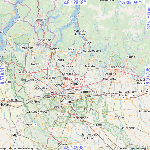
Macherio GPS coordinates[2]
45° 38' 23.064" North, 9° 16' 26.184" East
| Map corner | latitude | longitude |
|---|---|---|
| Upper-left | 46.12919°, | 8.57081° |
| Center: | 45.63974°, | 9.27394° |
| Lower-right: | 45.14598°, | 9.97706° |
| Map W x H: | 109.3×109.3 km | = 67.9×67.9mi |
| max Lat: | 47.04031° ⇑21.4% North |
| Macherio: | 45.63974° |
| min Lat: | ⇓78.6% South 35.50142° |
| min Long | Macherio | max Long |
| 6.69888° | 9.27394° | 18.48682° |
| W 23.2%⇐ | ⇒76.8% E |
Elevation
Elevation of Macherio is 214 m = 702 ft, and this is 92.7 m = 304 ft below average elevation for this country.
| Max E: |
2085 m = 6841 ft | 53.4% |
| Avg. | 306.7 m = 1006 ft | |
| Macherio | 214 m = 702 ft | |
Min E: |
-4 m = -13 ft | 46.6% |
See also: Italy elevation on elevation.city.
Geographical zone
Macherio is located in North temperate zone (between Tropic of Cancer and the Arctic Circle). Distance of this North polar circle is 2326.5 km =1445.6 mi to North.| Distance of | km | miles | from Macherio |
|---|---|---|---|
| North Pole | 4932.4 | 3064.9 | to North |
| Arctic Circle | 2326.5 | 1445.6 | to North |
| Tropic Cancer | 2468.7 | 1534 | to South |
| Equator | 5074.7 | 3153.3 | to South |


Nearby cities:
15 places around Macherio: (largest is in red/bold)
• Albiate
2.5 km =1.6 mi,  313°
313°
• Arcore
4.2 km =2.6 mi,  110°
110°
• Biassono
1.3 km =0.8 mi,  189°
189°
• Calò
4.5 km =2.8 mi,  349°
349°
• Camparada
4.2 km =2.6 mi,  66°
66°
• Campofiorenzo-California
4.6 km =2.9 mi,  47°
47°
• Canonica
2.1 km =1.3 mi,  30°
30°
• Correzzana
4 km =2.5 mi,  41°
41°
• Lesmo
2.8 km =1.7 mi, 69°
• Lissone
4 km =2.5 mi,  221°
221°
• Santa Margherita
3.5 km =2.2 mi,  259°
259°
• Sovico
1.1 km =0.7 mi, 308°
• Tregasio
4.4 km =2.7 mi,  14°
14°
• Triuggio
2.5 km =1.6 mi, 347°
• Vedano al Lambro
3.5 km =2.2 mi, 187°
Sources, notices
• [Note1] Compared only with cities in Italy existing in our database
• [Src1] Map data: © OpenStreetMap contributors (CC-BY-SA)
• [Src2] Other city data from geonames.org with taken over terms of usage.
• [Src3] Geographical zone / Annual Mean Temperature by Robert A. Rohde @ Wikipedia
