Altamura geodata
Altamura (Apulia) is a seat of a third-order administrative division; located in Italy in Europe/Rome (GMT+2) time zone. With population of 67,821 people, there are 73 cities with bigger population in this country. Compared to other cities in Italy, 81.1% of cities are located further ↑North; 96.7% of cities are located further ←West and 76.6% of cities have lower elevation than Altamura. Note1


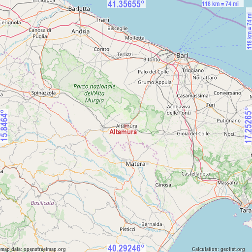
Altamura GPS coordinates[2]
40° 49' 35.904" North, 16° 32' 58.272" East
| Map corner | latitude | longitude |
|---|---|---|
| Upper-left | 41.35655°, | 15.8464° |
| Center: | 40.82664°, | 16.54952° |
| Lower-right: | 40.29246°, | 17.25265° |
| Map W x H: | 118.3×118.3 km | = 73.5×73.5mi |
| max Lat: | 47.04031° ⇑81.1% North |
| Altamura: | 40.82664° |
| min Lat: | ⇓18.9% South 35.50142° |
| min Long | Altamura | max Long |
| 6.69888° | 16.54952° | 18.48682° |
| W 96.7%⇐ | ⇒3.3% E |
Elevation
Elevation of Altamura is 475 m = 1558 ft, and this is 168.3 m = 552 ft above average elevation for this country.
| Max E: |
2085 m = 6841 ft | 23.4% |
| Altamura | 475 m 1558 ft | |
| Avg. | 306.7 m = 1006 ft | |
Min E: |
-4 m = -13 ft | 76.6% |
See also: Altamura elevation on elevation.city.
Geographical zone
Altamura is located in North temperate zone (between Tropic of Cancer and the Arctic Circle). Distance of this Northern Tropic circle is 1933.6 km =1201.5 mi to South.| Distance of | km | miles | from Altamura |
|---|---|---|---|
| North Pole | 5467.6 | 3397.4 | to North |
| Arctic Circle | 2861.7 | 1778.2 | to North |
| Tropic Cancer | 1933.6 | 1201.5 | to South |
| Equator | 4539.5 | 2820.7 | to South |


Nearby cities:
15 places around Altamura: (largest is in red/bold)
• Acquaviva delle Fonti
25.9 km =16.1 mi,  72°
72°
• Auricarro
26.5 km =16.5 mi,  25°
25°
• Binetto
25.7 km =16 mi, 31°
• Borgo Fra' Diavolo
16.2 km =10.1 mi, 65°
• Cassano delle Murge
19.5 km =12.1 mi, 68°
• Gravina in Puglia
11 km =6.8 mi,  264°
264°
• Grumo Appula
24.5 km =15.2 mi, 33°
• La Martella
18.3 km =11.4 mi,  183°
183°
• Mariotto
24.9 km =15.5 mi,  2°
2°
• Matera
18.5 km =11.5 mi,  165°
165°
• Palombaio
27.6 km =17.1 mi,  10°
10°
• Poggiorsini
26.5 km =16.5 mi,  291°
291°
• Quasano
15.8 km =9.8 mi, 7°
• Santeramo in Colle
18 km =11.2 mi,  102°
102°
• Toritto
21.9 km =13.6 mi, 29°
Sources, notices
• [Note1] Compared only with cities in Italy existing in our database
• [Src1] Map data: © OpenStreetMap contributors (CC-BY-SA)
• [Src2] Other city data from geonames.org with taken over terms of usage.
• [Src3] Geographical zone / Annual Mean Temperature by Robert A. Rohde @ Wikipedia
