Matera geodata
Matera (Basilicate) is a seat of a second-order administrative division; located in Italy in Europe/Rome (GMT+2) time zone. With population of 54,891 people, there are 98 cities with bigger population in this country. Compared to other cities in Italy, 82.8% of cities are located further ↑North; 97% of cities are located further ←West and 70.5% of cities have lower elevation than Matera. Note1


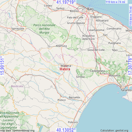
Matera GPS coordinates[2]
40° 39' 57.564" North, 16° 36' 16.668" East
| Map corner | latitude | longitude |
|---|---|---|
| Upper-left | 41.19719°, | 15.90151° |
| Center: | 40.66599°, | 16.60463° |
| Lower-right: | 40.13052°, | 17.30776° |
| Map W x H: | 118.6×118.6 km | = 73.7×73.7mi |
| max Lat: | 47.04031° ⇑82.8% North |
| Matera: | 40.66599° |
| min Lat: | ⇓17.2% South 35.50142° |
| min Long | Matera | max Long |
| 6.69888° | 16.60463° | 18.48682° |
| W 97%⇐ | ⇒3% E |
Elevation
Elevation of Matera is 399 m = 1309 ft, and this is 92.3 m = 303 ft above average elevation for this country.
| Max E: |
2085 m = 6841 ft | 29.5% |
| Matera | 399 m 1309 ft | |
| Avg. | 306.7 m = 1006 ft | |
Min E: |
-4 m = -13 ft | 70.5% |
See also: Matera elevation on elevation.city.
Geographical zone
Matera is located in North temperate zone (between Tropic of Cancer and the Arctic Circle). Distance of this Northern Tropic circle is 1915.7 km =1190.4 mi to South.| Distance of | km | miles | from Matera |
|---|---|---|---|
| North Pole | 5485.4 | 3408.5 | to North |
| Arctic Circle | 2879.5 | 1789.2 | to North |
| Tropic Cancer | 1915.7 | 1190.4 | to South |
| Equator | 4521.6 | 2809.6 | to South |


Nearby cities:
15 places around Matera: (largest is in red/bold)
• Altamura
18.5 km =11.5 mi,  345°
345°
• Borgo Fra' Diavolo
26.5 km =16.5 mi,  22°
22°
• Castellaneta
28 km =17.4 mi,  98°
98°
• Ferrandina
22.4 km =13.9 mi,  214°
214°
• Ginosa
16.2 km =10.1 mi,  127°
127°
• Grassano
27.8 km =17.3 mi,  262°
262°
• Gravina in Puglia
23 km =14.3 mi,  317°
317°
• Grottole
20.3 km =12.6 mi,  249°
249°
• La Martella
5.8 km =3.6 mi,  266°
266°
• Laterza
16.9 km =10.5 mi, 104°
• Miglionico
14.1 km =8.8 mi,  219°
219°
• Montescaglioso
13.9 km =8.6 mi,  158°
158°
• Pisticci Scalo
27.7 km =17.2 mi,  189°
189°
• Pomarico
16.7 km =10.4 mi,  203°
203°
• Santeramo in Colle
19.1 km =11.9 mi,  42°
42°
Sources, notices
• [Note1] Compared only with cities in Italy existing in our database
• [Src1] Map data: © OpenStreetMap contributors (CC-BY-SA)
• [Src2] Other city data from geonames.org with taken over terms of usage.
• [Src3] Geographical zone / Annual Mean Temperature by Robert A. Rohde @ Wikipedia
