Poggiorsini geodata
Poggiorsini (Apulia) is a seat of a third-order administrative division; located in Italy in Europe/Rome (GMT+2) time zone. With population of 1,367 people, there are 5450 cities with bigger population in this country. Compared to other cities in Italy, 79.7% of cities are located further ↑North; 94.8% of cities are located further ←West and 75.3% of cities have lower elevation than Poggiorsini. Note1


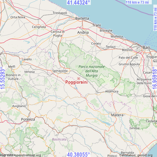
Poggiorsini GPS coordinates[2]
40° 54' 50.508" North, 16° 15' 21.78" East
| Map corner | latitude | longitude |
|---|---|---|
| Upper-left | 41.44324°, | 15.55293° |
| Center: | 40.91403°, | 16.25605° |
| Lower-right: | 40.38055°, | 16.95918° |
| Map W x H: | 118.2×118.2 km | = 73.4×73.4mi |
| max Lat: | 47.04031° ⇑79.7% North |
| Poggiorsini: | 40.91403° |
| min Lat: | ⇓20.3% South 35.50142° |
| min Long | Poggiorsini | max Long |
| 6.69888° | 16.25605° | 18.48682° |
| W 94.8%⇐ | ⇒5.2% E |
Elevation
Elevation of Poggiorsini is 456 m = 1496 ft, and this is 149.3 m = 490 ft above average elevation for this country.
| Max E: |
2085 m = 6841 ft | 24.7% |
| Poggiorsini | 456 m 1496 ft | |
| Avg. | 306.7 m = 1006 ft | |
Min E: |
-4 m = -13 ft | 75.3% |
See also: Italy elevation on elevation.city.
Geographical zone
Poggiorsini is located in North temperate zone (between Tropic of Cancer and the Arctic Circle). Distance of this Northern Tropic circle is 1943.3 km =1207.5 mi to South.| Distance of | km | miles | from Poggiorsini |
|---|---|---|---|
| North Pole | 5457.8 | 3391.3 | to North |
| Arctic Circle | 2852 | 1772.2 | to North |
| Tropic Cancer | 1943.3 | 1207.5 | to South |
| Equator | 4549.2 | 2826.7 | to South |


Nearby cities:
15 places around Poggiorsini: (largest is in red/bold)
• Acerenza
29.9 km =18.6 mi,  243°
243°
• Altamura
26.5 km =16.5 mi,  111°
111°
• Banzi
21.5 km =13.4 mi,  253°
253°
• Corato
29.5 km =18.3 mi,  26°
26°
• Genzano di Lucania
20.4 km =12.7 mi, 248°
• Gravina in Puglia
17.4 km =10.8 mi,  128°
128°
• Irsina
18.3 km =11.4 mi,  184°
184°
• Mariotto
29.8 km =18.5 mi,  59°
59°
• Minervino Murge
23.9 km =14.9 mi,  321°
321°
• Montemilone
27.4 km =17 mi,  297°
297°
• Oppido Lucano
28.2 km =17.5 mi,  233°
233°
• Palazzo San Gervasio
23.1 km =14.4 mi,  274°
274°
• Quasano
27.3 km =17 mi,  77°
77°
• Ruvo di Puglia
29.6 km =18.4 mi,  40°
40°
• Spinazzola
14.9 km =9.3 mi,  291°
291°
Sources, notices
• [Note1] Compared only with cities in Italy existing in our database
• [Src1] Map data: © OpenStreetMap contributors (CC-BY-SA)
• [Src2] Other city data from geonames.org with taken over terms of usage.
• [Src3] Geographical zone / Annual Mean Temperature by Robert A. Rohde @ Wikipedia
