Albiano geodata
Albiano (Trentino-Alto Adige) is a seat of a third-order administrative division; located in Italy in Europe/Rome (GMT+2) time zone. With population of 1,492 people, there are 5134 cities with bigger population in this country. Compared to other cities in Italy, 94.8% of cities are located further ↓South; 54.5% of cities are located further →East and 86.7% of cities have lower elevation than Albiano. Note1
Administrative division(s):
- Level 1: Trentino-Alto Adige
- Level 2: Provincia autonoma di Trento
- Level 3: Albiano


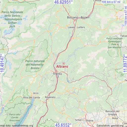
Albiano GPS coordinates[2]
46° 8' 40.236" North, 11° 11' 40.524" East
| Map corner | latitude | longitude |
|---|---|---|
| Upper-left | 46.62951°, | 10.49147° |
| Center: | 46.14451°, | 11.19459° |
| Lower-right: | 45.6552°, | 11.89772° |
| Map W x H: | 108.3×108.3 km | = 67.3×67.3mi |
| max Lat: | 47.04031° ⇑5.2% North |
| Albiano: | 46.14451° |
| min Lat: | ⇓94.8% South 35.50142° |
| min Long | Albiano | max Long |
| 6.69888° | 11.19459° | 18.48682° |
| W 45.5%⇐ | ⇒54.5% E |
Elevation
Elevation of Albiano is 646 m = 2119 ft, and this is 339.3 m = 1113 ft above average elevation for this country.
| Max E: |
2085 m = 6841 ft | 13.3% |
| Albiano | 646 m 2119 ft | |
| Avg. | 306.7 m = 1006 ft | |
Min E: |
-4 m = -13 ft | 86.7% |
See also: Italy elevation on elevation.city.
Geographical zone
Albiano is located in North temperate zone (between Tropic of Cancer and the Arctic Circle). Distance of this North polar circle is 2270.4 km =1410.8 mi to North.| Distance of | km | miles | from Albiano |
|---|---|---|---|
| North Pole | 4876.3 | 3030 | to North |
| Arctic Circle | 2270.4 | 1410.8 | to North |
| Tropic Cancer | 2524.9 | 1568.9 | to South |
| Equator | 5130.8 | 3188.1 | to South |


Nearby cities:
15 places around Albiano: (largest is in red/bold)
• Baselga di Pinè
4.2 km =2.6 mi,  108°
108°
• Cembra
4 km =2.5 mi,  31°
31°
• Faedo
5.9 km =3.7 mi,  334°
334°
• Faver
5.2 km =3.2 mi,  38°
38°
• Fornace
3.1 km =1.9 mi,  161°
161°
• Gazzadina
5.4 km =3.4 mi,  251°
251°
• Giovo
3.5 km =2.2 mi,  291°
291°
• Lases
1.9 km =1.2 mi,  86°
86°
• Lisignago
1.9 km =1.2 mi,  343°
343°
• Lona-Lases
1.9 km =1.2 mi, 90°
• Miola di Pinè
4.6 km =2.9 mi,  115°
115°
• Palù
4.4 km =2.7 mi, 290°
• Rizzolaga-Campolongo
6 km =3.7 mi,  84°
84°
• Verla
3.5 km =2.2 mi,  295°
295°
• Vigo Meano
4.8 km =3 mi,  255°
255°
Sources, notices
• [Note1] Compared only with cities in Italy existing in our database
• [Src1] Map data: © OpenStreetMap contributors (CC-BY-SA)
• [Src2] Other city data from geonames.org with taken over terms of usage.
• [Src3] Geographical zone / Annual Mean Temperature by Robert A. Rohde @ Wikipedia
