Cembra geodata
Cembra (Trentino-Alto Adige) is a seat of a third-order administrative division; located in Italy in Europe/Rome (GMT+2) time zone. With population of 1,802 people, there are 4484 cities with bigger population in this country. Compared to other cities in Italy, 95.7% of cities are located further ↓South; 54.2% of cities are located further →East and 87.4% of cities have lower elevation than Cembra. Note1
Administrative division(s):
- Level 1: Trentino-Alto Adige
- Level 2: Provincia autonoma di Trento
- Level 3: Cembra Lisignago


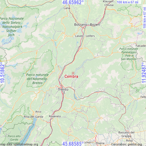
Cembra GPS coordinates[2]
46° 10' 29.604" North, 11° 13' 18.264" East
| Map corner | latitude | longitude |
|---|---|---|
| Upper-left | 46.65962°, | 10.51862° |
| Center: | 46.17489°, | 11.22174° |
| Lower-right: | 45.68585°, | 11.92487° |
| Map W x H: | 108.3×108.3 km | = 67.3×67.3mi |
| max Lat: | 47.04031° ⇑4.3% North |
| Cembra: | 46.17489° |
| min Lat: | ⇓95.7% South 35.50142° |
| min Long | Cembra | max Long |
| 6.69888° | 11.22174° | 18.48682° |
| W 45.8%⇐ | ⇒54.2% E |
Elevation
Elevation of Cembra is 661 m = 2169 ft, and this is 354.3 m = 1162 ft above average elevation for this country.
| Max E: |
2085 m = 6841 ft | 12.6% |
| Cembra | 661 m 2169 ft | |
| Avg. | 306.7 m = 1006 ft | |
Min E: |
-4 m = -13 ft | 87.4% |
See also: Italy elevation on elevation.city.
Geographical zone
Cembra is located in North temperate zone (between Tropic of Cancer and the Arctic Circle). Distance of this North polar circle is 2267 km =1408.6 mi to North.| Distance of | km | miles | from Cembra |
|---|---|---|---|
| North Pole | 4872.9 | 3027.9 | to North |
| Arctic Circle | 2267 | 1408.6 | to North |
| Tropic Cancer | 2528.2 | 1571 | to South |
| Equator | 5134.2 | 3190.2 | to South |


Nearby cities:
15 places around Cembra: (largest is in red/bold)
• Albiano
4 km =2.5 mi,  211°
211°
• Baselga di Pinè
5.1 km =3.2 mi,  157°
157°
• Centrale
6.4 km =4 mi,  103°
103°
• Faedo
5 km =3.1 mi,  292°
292°
• Faver
1.4 km =0.9 mi,  59°
59°
• Fornace
6.4 km =4 mi,  189°
189°
• Giovo
5.7 km =3.5 mi,  248°
248°
• Lases
3.3 km =2.1 mi,  183°
183°
• Lisignago
3.1 km =1.9 mi,  238°
238°
• Lona-Lases
3.4 km =2.1 mi, 182°
• Miola di Pinè
5.7 km =3.5 mi, 158°
• Rizzolaga-Campolongo
4.8 km =3 mi,  126°
126°
• Segonzano
3.4 km =2.1 mi, 59°
• Valda
4.9 km =3 mi,  42°
42°
• Verla
5.6 km =3.5 mi, 250°
Sources, notices
• [Note1] Compared only with cities in Italy existing in our database
• [Src1] Map data: © OpenStreetMap contributors (CC-BY-SA)
• [Src2] Other city data from geonames.org with taken over terms of usage.
• [Src3] Geographical zone / Annual Mean Temperature by Robert A. Rohde @ Wikipedia
