Tergu geodata
Tergu (Sardinia) is a seat of a third-order administrative division; located in Italy in Europe/Rome (GMT+2) time zone. With population of 362 people, there are 10429 cities with bigger population in this country. Compared to other cities in Italy, 80.5% of cities are located further ↑North; 85.3% of cities are located further →East and 56.8% of cities have lower elevation than Tergu. Note1


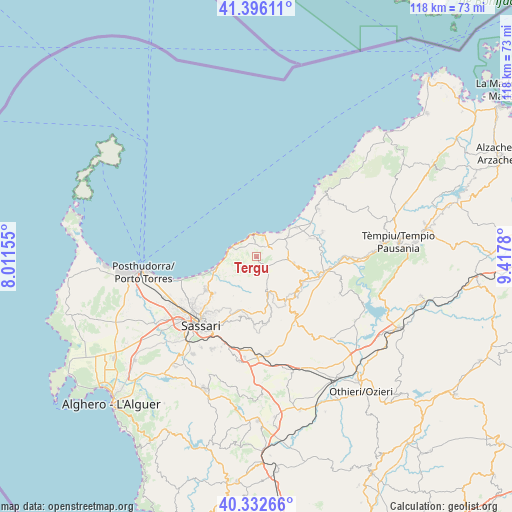
Tergu GPS coordinates[2]
40° 51' 59.472" North, 8° 42' 52.812" East
| Map corner | latitude | longitude |
|---|---|---|
| Upper-left | 41.39611°, | 8.01155° |
| Center: | 40.86652°, | 8.71467° |
| Lower-right: | 40.33266°, | 9.4178° |
| Map W x H: | 118.2×118.2 km | = 73.4×73.4mi |
| max Lat: | 47.04031° ⇑80.5% North |
| Tergu: | 40.86652° |
| min Lat: | ⇓19.5% South 35.50142° |
| min Long | Tergu | max Long |
| 6.69888° | 8.71467° | 18.48682° |
| W 14.7%⇐ | ⇒85.3% E |
Elevation
Elevation of Tergu is 277 m = 909 ft, and this is 29.7 m = 97 ft below average elevation for this country.
| Max E: |
2085 m = 6841 ft | 43.2% |
| Avg. | 306.7 m = 1006 ft | |
| Tergu | 277 m = 909 ft | |
Min E: |
-4 m = -13 ft | 56.8% |
See also: Italy elevation on elevation.city.
Geographical zone
Tergu is located in North temperate zone (between Tropic of Cancer and the Arctic Circle). Distance of this Northern Tropic circle is 1938 km =1204.2 mi to South.| Distance of | km | miles | from Tergu |
|---|---|---|---|
| North Pole | 5463.1 | 3394.6 | to North |
| Arctic Circle | 2857.2 | 1775.4 | to North |
| Tropic Cancer | 1938 | 1204.2 | to South |
| Equator | 4543.9 | 2823.4 | to South |


Nearby cities:
15 places around Tergu: (largest is in red/bold)
• Bulzi
10 km =6.2 mi,  102°
102°
• Castelsardo
5.1 km =3.2 mi,  359°
359°
• Codaruina
11.5 km =7.1 mi,  53°
53°
• La Muddizza
8.7 km =5.4 mi,  56°
56°
• Laerru
11.6 km =7.2 mi,  118°
118°
• Lu Bagnu
4.6 km =2.9 mi,  328°
328°
• Martis
12.6 km =7.8 mi,  141°
141°
• Nulvi
9.4 km =5.8 mi,  165°
165°
• Osilo
14.2 km =8.8 mi,  194°
194°
• Perfugas
14.7 km =9.1 mi, 104°
• Santa Maria Coghinas
13.2 km =8.2 mi,  71°
71°
• Sedini
8.7 km =5.4 mi, 100°
• Sennori
13.5 km =8.4 mi,  229°
229°
• Sorso
13.9 km =8.6 mi,  237°
237°
• Valledoria
11.4 km =7.1 mi, 52°
Sources, notices
• [Note1] Compared only with cities in Italy existing in our database
• [Src1] Map data: © OpenStreetMap contributors (CC-BY-SA)
• [Src2] Other city data from geonames.org with taken over terms of usage.
• [Src3] Geographical zone / Annual Mean Temperature by Robert A. Rohde @ Wikipedia
