Valledoria geodata
Valledoria (Sardinia) is a seat of a third-order administrative division; located in Italy in Europe/Rome (GMT+2) time zone. With population of 3,713 people, there are 2550 cities with bigger population in this country. Compared to other cities in Italy, 79.5% of cities are located further ↑North; 83.8% of cities are located further →East and 91.5% of cities have higher elevation than Valledoria. Note1


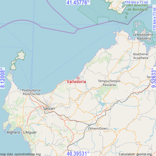
Valledoria GPS coordinates[2]
40° 55' 43.212" North, 8° 49' 23.556" East
| Map corner | latitude | longitude |
|---|---|---|
| Upper-left | 41.45776°, | 8.12008° |
| Center: | 40.92867°, | 8.82321° |
| Lower-right: | 40.39531°, | 9.52633° |
| Map W x H: | 118.1×118.1 km | = 73.4×73.4mi |
| max Lat: | 47.04031° ⇑79.5% North |
| Valledoria: | 40.92867° |
| min Lat: | ⇓20.5% South 35.50142° |
| min Long | Valledoria | max Long |
| 6.69888° | 8.82321° | 18.48682° |
| W 16.2%⇐ | ⇒83.8% E |
Elevation
Elevation of Valledoria is 15 m = 49 ft, and this is 291.7 m = 957 ft below average elevation for this country.
| Max E: |
2085 m = 6841 ft | 91.5% |
| Avg. | 306.7 m = 1006 ft | |
| Valledoria | 15 m = 49 ft | |
Min E: |
-4 m = -13 ft | 8.5% |
See also: Italy elevation on elevation.city.
Geographical zone
Valledoria is located in North temperate zone (between Tropic of Cancer and the Arctic Circle). Distance of this Northern Tropic circle is 1944.9 km =1208.5 mi to South.| Distance of | km | miles | from Valledoria |
|---|---|---|---|
| North Pole | 5456.2 | 3390.3 | to North |
| Arctic Circle | 2850.3 | 1771.1 | to North |
| Tropic Cancer | 1944.9 | 1208.5 | to South |
| Equator | 4550.8 | 2827.7 | to South |


Nearby cities:
15 places around Valledoria: (largest is in red/bold)
• Badesi
6.4 km =4 mi,  51°
51°
• Bulzi
9.1 km =5.7 mi,  176°
176°
• Castelsardo
9.3 km =5.8 mi,  258°
258°
• Codaruina
0.1 km =0.1 mi,  108°
108°
• La Muddizza
2.8 km =1.7 mi,  221°
221°
• Laerru
12.5 km =7.8 mi,  174°
174°
• Lu Bagnu
11.9 km =7.4 mi, 255°
• Martis
16.8 km =10.4 mi, 184°
• Perfugas
11.9 km =7.4 mi,  154°
154°
• Santa Maria Coghinas
4.4 km =2.7 mi,  128°
128°
• Sedini
8.5 km =5.3 mi, 183°
• Tergu
11.4 km =7.1 mi,  232°
232°
• Trinità d'Agultu
9.9 km =6.2 mi, 50°
• Trinità d'Agultu e Vignola
9.9 km =6.2 mi, 51°
• Viddalba
5.9 km =3.7 mi, 107°
Sources, notices
• [Note1] Compared only with cities in Italy existing in our database
• [Src1] Map data: © OpenStreetMap contributors (CC-BY-SA)
• [Src2] Other city data from geonames.org with taken over terms of usage.
• [Src3] Geographical zone / Annual Mean Temperature by Robert A. Rohde @ Wikipedia
