Sennori geodata
Sennori (Sardinia) is a seat of a third-order administrative division; located in Italy in Europe/Rome (GMT+2) time zone. With population of 6,855 people, there are 1422 cities with bigger population in this country. Compared to other cities in Italy, 81.5% of cities are located further ↑North; 86.8% of cities are located further →East and 52.8% of cities have lower elevation than Sennori. Note1


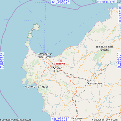
Sennori GPS coordinates[2]
40° 47' 16.08" North, 8° 35' 34.26" East
| Map corner | latitude | longitude |
|---|---|---|
| Upper-left | 41.31802°, | 7.88973° |
| Center: | 40.7878°, | 8.59285° |
| Lower-right: | 40.25331°, | 9.29598° |
| Map W x H: | 118.4×118.4 km | = 73.6×73.6mi |
| max Lat: | 47.04031° ⇑81.5% North |
| Sennori: | 40.7878° |
| min Lat: | ⇓18.5% South 35.50142° |
| min Long | Sennori | max Long |
| 6.69888° | 8.59285° | 18.48682° |
| W 13.2%⇐ | ⇒86.8% E |
Elevation
Elevation of Sennori is 252 m = 827 ft, and this is 54.7 m = 179 ft below average elevation for this country.
| Max E: |
2085 m = 6841 ft | 47.2% |
| Avg. | 306.7 m = 1006 ft | |
| Sennori | 252 m = 827 ft | |
Min E: |
-4 m = -13 ft | 52.8% |
See also: Italy elevation on elevation.city.
Geographical zone
Sennori is located in North temperate zone (between Tropic of Cancer and the Arctic Circle). Distance of this Northern Tropic circle is 1929.3 km =1198.8 mi to South.| Distance of | km | miles | from Sennori |
|---|---|---|---|
| North Pole | 5471.9 | 3400.1 | to North |
| Arctic Circle | 2866 | 1780.8 | to North |
| Tropic Cancer | 1929.3 | 1198.8 | to South |
| Equator | 4535.2 | 2818 | to South |


Nearby cities:
15 places around Sennori: (largest is in red/bold)
• Bancali
12.4 km =7.7 mi,  241°
241°
• Cargeghe
13.3 km =8.3 mi,  171°
171°
• Codrongianos
16.4 km =10.2 mi,  153°
153°
• Li Punti-San Giovanni
9.2 km =5.7 mi,  252°
252°
• Lu Bagnu
14.9 km =9.3 mi,  31°
31°
• Muros
12.3 km =7.6 mi, 170°
• Nulvi
12.7 km =7.9 mi,  91°
91°
• Osilo
8.2 km =5.1 mi,  126°
126°
• Ossi
12.6 km =7.8 mi,  180°
180°
• Ottava
9.9 km =6.2 mi,  268°
268°
• Sassari
7.6 km =4.7 mi,  204°
204°
• Sorso
1.9 km =1.2 mi,  311°
311°
• Tergu
13.5 km =8.4 mi,  49°
49°
• Tissi
12.5 km =7.8 mi,  192°
192°
• Usini
14.5 km =9 mi, 198°
Sources, notices
• [Note1] Compared only with cities in Italy existing in our database
• [Src1] Map data: © OpenStreetMap contributors (CC-BY-SA)
• [Src2] Other city data from geonames.org with taken over terms of usage.
• [Src3] Geographical zone / Annual Mean Temperature by Robert A. Rohde @ Wikipedia
