Russi geodata
Russi (Emilia-Romagna) is a seat of a third-order administrative division; located in Italy in Europe/Rome (GMT+2) time zone. With population of 6,697 people, there are 1470 cities with bigger population in this country. Compared to other cities in Italy, 50.8% of cities are located further ↑North; 56.3% of cities are located further ←West and 94.1% of cities have higher elevation than Russi. Note1


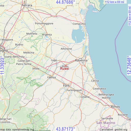
Russi GPS coordinates[2]
44° 22' 35.22" North, 12° 2' 0.06" East
| Map corner | latitude | longitude |
|---|---|---|
| Upper-left | 44.87686°, | 11.33023° |
| Center: | 44.37645°, | 12.03335° |
| Lower-right: | 43.87173°, | 12.73648° |
| Map W x H: | 111.8×111.8 km | = 69.5×69.5mi |
| max Lat: | 47.04031° ⇑50.8% North |
| Russi: | 44.37645° |
| min Lat: | ⇓49.2% South 35.50142° |
| min Long | Russi | max Long |
| 6.69888° | 12.03335° | 18.48682° |
| W 56.3%⇐ | ⇒43.7% E |
Elevation
Elevation of Russi is 10 m = 33 ft, and this is 296.7 m = 973 ft below average elevation for this country.
| Max E: |
2085 m = 6841 ft | 94.1% |
| Avg. | 306.7 m = 1006 ft | |
| Russi | 10 m = 33 ft | |
Min E: |
-4 m = -13 ft | 5.9% |
See also: Italy elevation on elevation.city.
Geographical zone
Russi is located in North temperate zone (between Tropic of Cancer and the Arctic Circle). Distance of this Northern Tropic circle is 2328.3 km =1446.7 mi to South.| Distance of | km | miles | from Russi |
|---|---|---|---|
| North Pole | 5072.9 | 3152.2 | to North |
| Arctic Circle | 2467 | 1532.9 | to North |
| Tropic Cancer | 2328.3 | 1446.7 | to South |
| Equator | 4934.2 | 3066 | to South |


Nearby cities:
15 places around Russi: (largest is in red/bold)
• Alfonsine
9.6 km =6 mi,  22°
22°
• Bagnacavallo
6.1 km =3.8 mi,  313°
313°
• Cotignola
7.6 km =4.7 mi,  277°
277°
• Fornace Zarattini
9.1 km =5.7 mi,  60°
60°
• Godo
3.7 km =2.3 mi, 62°
• Granarolo
8.1 km =5 mi,  255°
255°
• Piangipane
6.8 km =4.2 mi,  41°
41°
• Roncalceci
7.5 km =4.7 mi,  115°
115°
• San Michele
7 km =4.3 mi, 63°
• San Pancrazio
4.1 km =2.5 mi, 119°
• San Pietro in Trento
7.6 km =4.7 mi,  149°
149°
• San Potito
9.7 km =6 mi, 309°
• Santerno
7 km =4.3 mi,  14°
14°
• Villanova
6.6 km =4.1 mi,  85°
85°
• Villanova
8.1 km =5 mi, 9°
Sources, notices
• [Note1] Compared only with cities in Italy existing in our database
• [Src1] Map data: © OpenStreetMap contributors (CC-BY-SA)
• [Src2] Other city data from geonames.org with taken over terms of usage.
• [Src3] Geographical zone / Annual Mean Temperature by Robert A. Rohde @ Wikipedia
