Summaga geodata
Summaga (Veneto) is a populated place; located in Italy in Europe/Rome (GMT+2) time zone. With population of 1,610 people, there are 4881 cities with bigger population in this country. Compared to other cities in Italy, 84.6% of cities are located further ↓South; 66.1% of cities are located further ←West and 98.4% of cities have higher elevation than Summaga. Note1


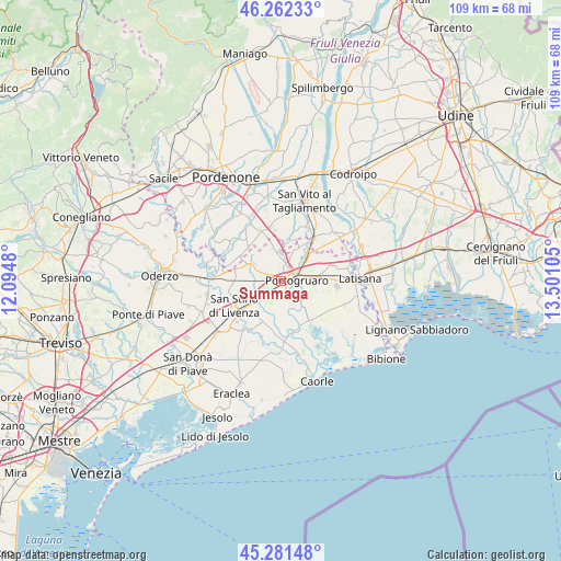
Summaga GPS coordinates[2]
45° 46' 26.616" North, 12° 47' 52.512" East
| Map corner | latitude | longitude |
|---|---|---|
| Upper-left | 46.26233°, | 12.0948° |
| Center: | 45.77406°, | 12.79792° |
| Lower-right: | 45.28148°, | 13.50105° |
| Map W x H: | 109.1×109.1 km | = 67.8×67.8mi |
| max Lat: | 47.04031° ⇑15.4% North |
| Summaga: | 45.77406° |
| min Lat: | ⇓84.6% South 35.50142° |
| min Long | Summaga | max Long |
| 6.69888° | 12.79792° | 18.48682° |
| W 66.1%⇐ | ⇒33.9% E |
Elevation
Elevation of Summaga is 3 m = 10 ft, and this is 303.7 m = 996 ft below average elevation for this country.
| Max E: |
2085 m = 6841 ft | 98.4% |
| Avg. | 306.7 m = 1006 ft | |
| Summaga | 3 m = 10 ft | |
Min E: |
-4 m = -13 ft | 1.6% |
See also: Italy elevation on elevation.city.
Geographical zone
Summaga is located in North temperate zone (between Tropic of Cancer and the Arctic Circle). Distance of this North polar circle is 2311.6 km =1436.4 mi to North.| Distance of | km | miles | from Summaga |
|---|---|---|---|
| North Pole | 4917.5 | 3055.6 | to North |
| Arctic Circle | 2311.6 | 1436.4 | to North |
| Tropic Cancer | 2483.7 | 1543.3 | to South |
| Equator | 5089.6 | 3162.5 | to South |


Nearby cities:
15 places around Summaga: (largest is in red/bold)
• Belfiore
5.6 km =3.5 mi,  281°
281°
• Cintello
7.1 km =4.4 mi,  46°
46°
• Cinto Caomaggiore
6.1 km =3.8 mi,  347°
347°
• Concordia Sagittaria
2.5 km =1.6 mi,  125°
125°
• Giai
4.7 km =2.9 mi,  21°
21°
• Gruaro
7.5 km =4.7 mi,  26°
26°
• Gruaro-Bagnara
8.6 km =5.3 mi, 28°
• Portogruaro
3.4 km =2.1 mi,  77°
77°
• Pradipozzo
3.1 km =1.9 mi, 281°
• Pramaggiore
6.5 km =4 mi,  314°
314°
• Pramaggiore Blessaglia
6.6 km =4.1 mi,  301°
301°
• Sesto al Reghena
8.5 km =5.3 mi,  7°
7°
• Stiago
7.1 km =4.4 mi,  88°
88°
• Teglio Veneto
8.2 km =5.1 mi, 54°
• Villanova Santa Margherita
7.6 km =4.7 mi,  95°
95°
Sources, notices
• [Note1] Compared only with cities in Italy existing in our database
• [Src1] Map data: © OpenStreetMap contributors (CC-BY-SA)
• [Src2] Other city data from geonames.org with taken over terms of usage.
• [Src3] Geographical zone / Annual Mean Temperature by Robert A. Rohde @ Wikipedia
