Cintello geodata
Cintello (Veneto) is a populated place; located in Italy in Europe/Rome (GMT+2) time zone. With population of 536 people, there are 9588 cities with bigger population in this country. Compared to other cities in Italy, 86.6% of cities are located further ↓South; 66.8% of cities are located further ←West and 94.8% of cities have higher elevation than Cintello. Note1


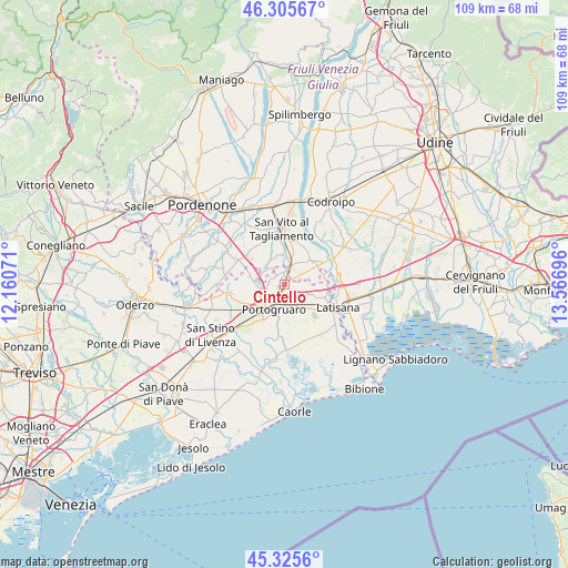
Cintello GPS coordinates[2]
45° 49' 4.044" North, 12° 51' 49.788" East
| Map corner | latitude | longitude |
|---|---|---|
| Upper-left | 46.30567°, | 12.16071° |
| Center: | 45.81779°, | 12.86383° |
| Lower-right: | 45.3256°, | 13.56696° |
| Map W x H: | 109×109 km | = 67.7×67.7mi |
| max Lat: | 47.04031° ⇑13.4% North |
| Cintello: | 45.81779° |
| min Lat: | ⇓86.6% South 35.50142° |
| min Long | Cintello | max Long |
| 6.69888° | 12.86383° | 18.48682° |
| W 66.8%⇐ | ⇒33.2% E |
Elevation
Elevation of Cintello is 9 m = 30 ft, and this is 297.7 m = 977 ft below average elevation for this country.
| Max E: |
2085 m = 6841 ft | 94.8% |
| Avg. | 306.7 m = 1006 ft | |
| Cintello | 9 m = 30 ft | |
Min E: |
-4 m = -13 ft | 5.2% |
See also: Italy elevation on elevation.city.
Geographical zone
Cintello is located in North temperate zone (between Tropic of Cancer and the Arctic Circle). Distance of this North polar circle is 2306.7 km =1433.3 mi to North.| Distance of | km | miles | from Cintello |
|---|---|---|---|
| North Pole | 4912.6 | 3052.5 | to North |
| Arctic Circle | 2306.7 | 1433.3 | to North |
| Tropic Cancer | 2488.5 | 1546.3 | to South |
| Equator | 5094.5 | 3165.6 | to South |


Nearby cities:
15 places around Cintello: (largest is in red/bold)
• Bagnarola
5.5 km =3.4 mi,  355°
355°
• Casette
4.2 km =2.6 mi,  17°
17°
• Cinto Caomaggiore
6.5 km =4 mi,  279°
279°
• Concordia Sagittaria
7 km =4.3 mi,  206°
206°
• Cordovado
3.4 km =2.1 mi,  29°
29°
• Fossalta di Portogruaro
4.5 km =2.8 mi,  127°
127°
• Giai
3.4 km =2.1 mi,  262°
262°
• Gruaro
2.6 km =1.6 mi,  316°
316°
• Gruaro-Bagnara
2.8 km =1.7 mi,  339°
339°
• Morsano
6.8 km =4.2 mi,  46°
46°
• Portogruaro
4.5 km =2.8 mi,  203°
203°
• Sesto al Reghena
5.3 km =3.3 mi,  311°
311°
• Stiago
5.1 km =3.2 mi,  156°
156°
• Teglio Veneto
1.6 km =1 mi,  95°
95°
• Villanova Santa Margherita
6.1 km =3.8 mi, 156°
Sources, notices
• [Note1] Compared only with cities in Italy existing in our database
• [Src1] Map data: © OpenStreetMap contributors (CC-BY-SA)
• [Src2] Other city data from geonames.org with taken over terms of usage.
• [Src3] Geographical zone / Annual Mean Temperature by Robert A. Rohde @ Wikipedia
