Gruaro geodata
Gruaro (Veneto) is a seat of a third-order administrative division; located in Italy in Europe/Rome (GMT+2) time zone. With population of 2,690 people, there are 3315 cities with bigger population in this country. Compared to other cities in Italy, 87.2% of cities are located further ↓South; 66.5% of cities are located further ←West and 96.6% of cities have higher elevation than Gruaro. Note1


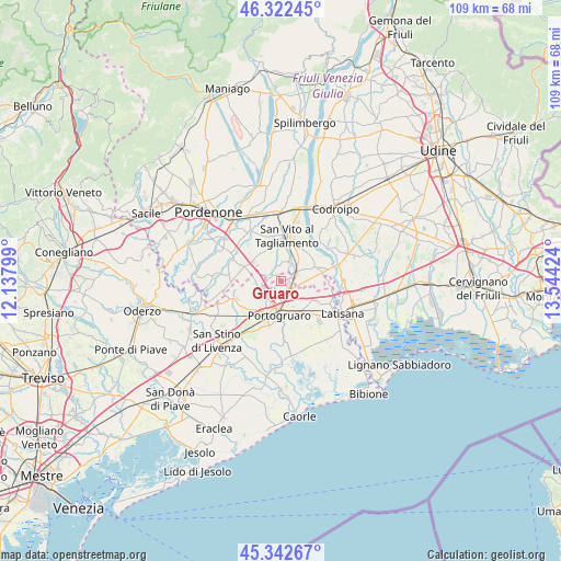
Gruaro GPS coordinates[2]
45° 50' 4.992" North, 12° 50' 27.996" East
| Map corner | latitude | longitude |
|---|---|---|
| Upper-left | 46.32245°, | 12.13799° |
| Center: | 45.83472°, | 12.84111° |
| Lower-right: | 45.34267°, | 13.54424° |
| Map W x H: | 108.9×108.9 km | = 67.7×67.7mi |
| max Lat: | 47.04031° ⇑12.8% North |
| Gruaro: | 45.83472° |
| min Lat: | ⇓87.2% South 35.50142° |
| min Long | Gruaro | max Long |
| 6.69888° | 12.84111° | 18.48682° |
| W 66.5%⇐ | ⇒33.5% E |
Elevation
Elevation of Gruaro is 6 m = 20 ft, and this is 300.7 m = 987 ft below average elevation for this country.
| Max E: |
2085 m = 6841 ft | 96.6% |
| Avg. | 306.7 m = 1006 ft | |
| Gruaro | 6 m = 20 ft | |
Min E: |
-4 m = -13 ft | 3.4% |
See also: Italy elevation on elevation.city.
Geographical zone
Gruaro is located in North temperate zone (between Tropic of Cancer and the Arctic Circle). Distance of this North polar circle is 2304.8 km =1432.1 mi to North.| Distance of | km | miles | from Gruaro |
|---|---|---|---|
| North Pole | 4910.7 | 3051.4 | to North |
| Arctic Circle | 2304.8 | 1432.1 | to North |
| Tropic Cancer | 2490.4 | 1547.5 | to South |
| Equator | 5096.3 | 3166.7 | to South |


Nearby cities:
15 places around Gruaro: (largest is in red/bold)
• Bagnarola
3.8 km =2.4 mi,  21°
21°
• Casette
3.7 km =2.3 mi,  54°
54°
• Cintello
2.6 km =1.6 mi,  136°
136°
• Cinto Caomaggiore
4.7 km =2.9 mi,  260°
260°
• Cordovado
3.6 km =2.2 mi,  72°
72°
• Fossalta di Portogruaro
7.1 km =4.4 mi,  130°
130°
• Giai
2.8 km =1.7 mi,  215°
215°
• Gleris
7.3 km =4.5 mi, 20°
• Gruaro-Bagnara
1.1 km =0.7 mi, 45°
• Morsano
7.3 km =4.5 mi, 67°
• Portogruaro
6 km =3.7 mi,  180°
180°
• Ramuscello
6.2 km =3.9 mi,  33°
33°
• Savorgnano
6.9 km =4.3 mi,  7°
7°
• Sesto al Reghena
2.7 km =1.7 mi,  306°
306°
• Teglio Veneto
3.9 km =2.4 mi,  121°
121°
Sources, notices
• [Note1] Compared only with cities in Italy existing in our database
• [Src1] Map data: © OpenStreetMap contributors (CC-BY-SA)
• [Src2] Other city data from geonames.org with taken over terms of usage.
• [Src3] Geographical zone / Annual Mean Temperature by Robert A. Rohde @ Wikipedia
