Fagarè geodata
Fagarè (Veneto) is a populated place; located in Italy in Europe/Rome (GMT+2) time zone. With population of 550 people, there are 9451 cities with bigger population in this country. Compared to other cities in Italy, 81.5% of cities are located further ↓South; 61.6% of cities are located further ←West and 94.8% of cities have higher elevation than Fagarè. Note1
Administrative division(s):
- Level 1: Veneto
- Level 2: Provincia di Treviso
- Level 3: San Biagio di Callalta


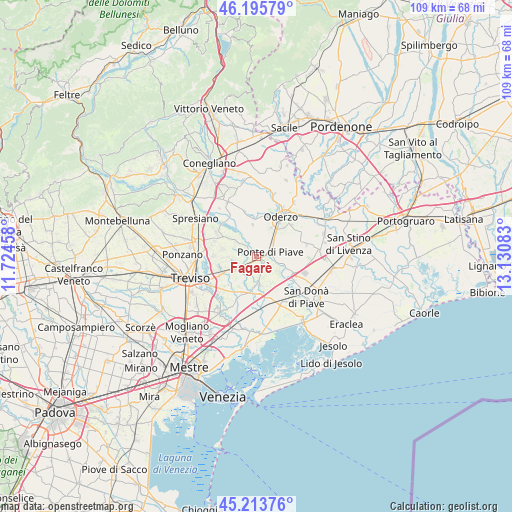
Fagarè GPS coordinates[2]
45° 42' 24.948" North, 12° 25' 39.72" East
| Map corner | latitude | longitude |
|---|---|---|
| Upper-left | 46.19579°, | 11.72458° |
| Center: | 45.70693°, | 12.4277° |
| Lower-right: | 45.21376°, | 13.13083° |
| Map W x H: | 109.2×109.2 km | = 67.9×67.9mi |
| max Lat: | 47.04031° ⇑18.5% North |
| Fagarè: | 45.70693° |
| min Lat: | ⇓81.5% South 35.50142° |
| min Long | Fagarè | max Long |
| 6.69888° | 12.4277° | 18.48682° |
| W 61.6%⇐ | ⇒38.4% E |
Elevation
Elevation of Fagarè is 9 m = 30 ft, and this is 297.7 m = 977 ft below average elevation for this country.
| Max E: |
2085 m = 6841 ft | 94.8% |
| Avg. | 306.7 m = 1006 ft | |
| Fagarè | 9 m = 30 ft | |
Min E: |
-4 m = -13 ft | 5.2% |
See also: Italy elevation on elevation.city.
Geographical zone
Fagarè is located in North temperate zone (between Tropic of Cancer and the Arctic Circle). Distance of this North polar circle is 2319 km =1441 mi to North.| Distance of | km | miles | from Fagarè |
|---|---|---|---|
| North Pole | 4924.9 | 3060.2 | to North |
| Arctic Circle | 2319 | 1441 | to North |
| Tropic Cancer | 2476.2 | 1538.6 | to South |
| Equator | 5082.1 | 3157.9 | to South |


Nearby cities:
15 places around Fagarè: (largest is in red/bold)
• Bocca Callalta
1.2 km =0.7 mi,  100°
100°
• Candelù
5.3 km =3.3 mi,  305°
305°
• Cavrie
4.5 km =2.8 mi,  265°
265°
• Levada
4.6 km =2.9 mi,  47°
47°
• Monastier di Treviso
5.5 km =3.4 mi,  188°
188°
• Negrisia
3 km =1.9 mi,  12°
12°
• Ponte di Piave
3 km =1.9 mi,  63°
63°
• Roncadelle
5.8 km =3.6 mi,  346°
346°
• Rovarè
3.6 km =2.2 mi,  210°
210°
• Saletto-San Bartolomeo
3.3 km =2.1 mi, 310°
• Salgareda
4.7 km =2.9 mi,  92°
92°
• San Biagio di Callalta
4.7 km =2.9 mi,  236°
236°
• Talponada
4.9 km =3 mi, 94°
• Vigonovo di Sopra
3.6 km =2.2 mi,  72°
72°
• Zenson di Piave
5.7 km =3.5 mi,  122°
122°
Sources, notices
• [Note1] Compared only with cities in Italy existing in our database
• [Src1] Map data: © OpenStreetMap contributors (CC-BY-SA)
• [Src2] Other city data from geonames.org with taken over terms of usage.
• [Src3] Geographical zone / Annual Mean Temperature by Robert A. Rohde @ Wikipedia
