Povegliano geodata
Povegliano (Veneto) is a seat of a third-order administrative division; located in Italy in Europe/Rome (GMT+2) time zone. With population of 1,195 people, there are 5975 cities with bigger population in this country. Compared to other cities in Italy, 84% of cities are located further ↓South; 58.7% of cities are located further ←West and 79% of cities have higher elevation than Povegliano. Note1


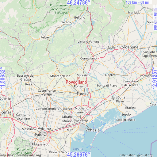
Povegliano GPS coordinates[2]
45° 45' 34.092" North, 12° 12' 33.984" East
| Map corner | latitude | longitude |
|---|---|---|
| Upper-left | 46.24786°, | 11.50632° |
| Center: | 45.75947°, | 12.20944° |
| Lower-right: | 45.26676°, | 12.91257° |
| Map W x H: | 109.1×109.1 km | = 67.8×67.8mi |
| max Lat: | 47.04031° ⇑16% North |
| Povegliano: | 45.75947° |
| min Lat: | ⇓84% South 35.50142° |
| min Long | Povegliano | max Long |
| 6.69888° | 12.20944° | 18.48682° |
| W 58.7%⇐ | ⇒41.3% E |
Elevation
Elevation of Povegliano is 54 m = 177 ft, and this is 252.7 m = 829 ft below average elevation for this country.
| Max E: |
2085 m = 6841 ft | 79% |
| Avg. | 306.7 m = 1006 ft | |
| Povegliano | 54 m = 177 ft | |
Min E: |
-4 m = -13 ft | 21% |
See also: Italy elevation on elevation.city.
Geographical zone
Povegliano is located in North temperate zone (between Tropic of Cancer and the Arctic Circle). Distance of this North polar circle is 2313.2 km =1437.4 mi to North.| Distance of | km | miles | from Povegliano |
|---|---|---|---|
| North Pole | 4919.1 | 3056.6 | to North |
| Arctic Circle | 2313.2 | 1437.4 | to North |
| Tropic Cancer | 2482.1 | 1542.3 | to South |
| Equator | 5088 | 3161.5 | to South |


Nearby cities:
15 places around Povegliano: (largest is in red/bold)
• Arcade
2.9 km =1.8 mi,  16°
16°
• Bidasio
6.3 km =3.9 mi, 22°
• Camalò
3 km =1.9 mi,  256°
256°
• Giavera del Montello
5.1 km =3.2 mi,  318°
318°
• Lancenigo-Villorba
6.4 km =4 mi,  144°
144°
• Nervesa della Battaglia
5.9 km =3.7 mi,  351°
351°
• Ponzano
4.9 km =3 mi,  184°
184°
• Postioma
6.4 km =4 mi,  223°
223°
• Priula-Colfosco
7.7 km =4.8 mi,  29°
29°
• San Rocco
1.7 km =1.1 mi, 322°
• Santandrà
1.5 km =0.9 mi,  206°
206°
• Selva del Montello
6 km =3.7 mi,  302°
302°
• Spresiano
4.2 km =2.6 mi,  59°
59°
• Visnadello
2.9 km =1.8 mi,  91°
91°
• Volpago del Montello
7.3 km =4.5 mi,  286°
286°
Sources, notices
• [Note1] Compared only with cities in Italy existing in our database
• [Src1] Map data: © OpenStreetMap contributors (CC-BY-SA)
• [Src2] Other city data from geonames.org with taken over terms of usage.
• [Src3] Geographical zone / Annual Mean Temperature by Robert A. Rohde @ Wikipedia
