Santandrà geodata
Santandrà (Veneto) is a populated place; located in Italy in Europe/Rome (GMT+2) time zone. With population of 1,102 people, there are 6286 cities with bigger population in this country. Compared to other cities in Italy, 83.4% of cities are located further ↓South; 58.6% of cities are located further ←West and 80.9% of cities have higher elevation than Santandrà. Note1


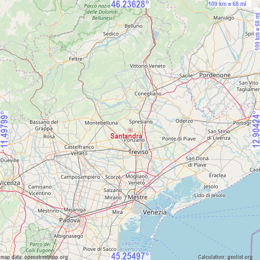
Santandrà GPS coordinates[2]
45° 44' 52.008" North, 12° 12' 3.996" East
| Map corner | latitude | longitude |
|---|---|---|
| Upper-left | 46.23628°, | 11.49799° |
| Center: | 45.74778°, | 12.20111° |
| Lower-right: | 45.25497°, | 12.90424° |
| Map W x H: | 109.1×109.1 km | = 67.8×67.8mi |
| max Lat: | 47.04031° ⇑16.6% North |
| Santandrà: | 45.74778° |
| min Lat: | ⇓83.4% South 35.50142° |
| min Long | Santandrà | max Long |
| 6.69888° | 12.20111° | 18.48682° |
| W 58.6%⇐ | ⇒41.4% E |
Elevation
Elevation of Santandrà is 46 m = 151 ft, and this is 260.7 m = 855 ft below average elevation for this country.
| Max E: |
2085 m = 6841 ft | 80.9% |
| Avg. | 306.7 m = 1006 ft | |
| Santandrà | 46 m = 151 ft | |
Min E: |
-4 m = -13 ft | 19.1% |
See also: Italy elevation on elevation.city.
Geographical zone
Santandrà is located in North temperate zone (between Tropic of Cancer and the Arctic Circle). Distance of this North polar circle is 2314.5 km =1438.2 mi to North.| Distance of | km | miles | from Santandrà |
|---|---|---|---|
| North Pole | 4920.4 | 3057.4 | to North |
| Arctic Circle | 2314.5 | 1438.2 | to North |
| Tropic Cancer | 2480.8 | 1541.5 | to South |
| Equator | 5086.7 | 3160.7 | to South |


Nearby cities:
15 places around Santandrà: (largest is in red/bold)
• Arcade
4.3 km =2.7 mi,  19°
19°
• Camalò
2.4 km =1.5 mi,  284°
284°
• Castagnole
6.7 km =4.2 mi,  192°
192°
• Giavera del Montello
5.8 km =3.6 mi,  332°
332°
• Lancenigo-Villorba
5.8 km =3.6 mi,  131°
131°
• Musano
6.9 km =4.3 mi,  249°
249°
• Ponzano
3.6 km =2.2 mi,  175°
175°
• Porcellengo
6.5 km =4 mi,  224°
224°
• Postioma
5.1 km =3.2 mi,  228°
228°
• Povegliano
1.5 km =0.9 mi,  26°
26°
• San Rocco
2.7 km =1.7 mi,  351°
351°
• Selva del Montello
6.3 km =3.9 mi,  315°
315°
• Spresiano
5.5 km =3.4 mi,  50°
50°
• Visnadello
3.7 km =2.3 mi,  70°
70°
• Volpago del Montello
7.2 km =4.5 mi,  297°
297°
Sources, notices
• [Note1] Compared only with cities in Italy existing in our database
• [Src1] Map data: © OpenStreetMap contributors (CC-BY-SA)
• [Src2] Other city data from geonames.org with taken over terms of usage.
• [Src3] Geographical zone / Annual Mean Temperature by Robert A. Rohde @ Wikipedia
