Brugine geodata
Brugine (Veneto) is a seat of a third-order administrative division; located in Italy in Europe/Rome (GMT+2) time zone. With population of 2,249 people, there are 3816 cities with bigger population in this country. Compared to other cities in Italy, 67.4% of cities are located further ↓South; 55.8% of cities are located further ←West and 96.6% of cities have higher elevation than Brugine. Note1


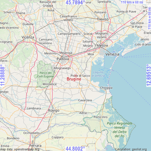
Brugine GPS coordinates[2]
45° 17' 49.056" North, 11° 59' 31.2" East
| Map corner | latitude | longitude |
|---|---|---|
| Upper-left | 45.7894°, | 11.28888° |
| Center: | 45.29696°, | 11.992° |
| Lower-right: | 44.8002°, | 12.69513° |
| Map W x H: | 110×110 km | = 68.4×68.4mi |
| max Lat: | 47.04031° ⇑32.6% North |
| Brugine: | 45.29696° |
| min Lat: | ⇓67.4% South 35.50142° |
| min Long | Brugine | max Long |
| 6.69888° | 11.992° | 18.48682° |
| W 55.8%⇐ | ⇒44.2% E |
Elevation
Elevation of Brugine is 6 m = 20 ft, and this is 300.7 m = 987 ft below average elevation for this country.
| Max E: |
2085 m = 6841 ft | 96.6% |
| Avg. | 306.7 m = 1006 ft | |
| Brugine | 6 m = 20 ft | |
Min E: |
-4 m = -13 ft | 3.4% |
See also: Italy elevation on elevation.city.
Geographical zone
Brugine is located in North temperate zone (between Tropic of Cancer and the Arctic Circle). Distance of this North polar circle is 2364.6 km =1469.3 mi to North.| Distance of | km | miles | from Brugine |
|---|---|---|---|
| North Pole | 4970.5 | 3088.5 | to North |
| Arctic Circle | 2364.6 | 1469.3 | to North |
| Tropic Cancer | 2430.6 | 1510.3 | to South |
| Equator | 5036.5 | 3129.5 | to South |


Nearby cities:
15 places around Brugine: (largest is in red/bold)
• Arzercavalli
7.2 km =4.5 mi,  215°
215°
• Arzerello
3.7 km =2.3 mi,  134°
134°
• Arzergrande
5.2 km =3.2 mi,  121°
121°
• Bovolenta
5.4 km =3.4 mi,  234°
234°
• Campagnola
2.1 km =1.3 mi,  164°
164°
• Campolongo Maggiore
5 km =3.1 mi,  53°
53°
• Campolongo Maggiore Liettoli
5.4 km =3.4 mi,  28°
28°
• Casalserugo
6.6 km =4.1 mi,  288°
288°
• Corte
6.4 km =4 mi,  78°
78°
• Legnaro
5.5 km =3.4 mi,  337°
337°
• Piove di Sacco-Piovega
3.5 km =2.2 mi,  90°
90°
• Polverara
3.2 km =2 mi,  295°
295°
• Pontelongo
6.3 km =3.9 mi, 155°
• Roncajette
6.9 km =4.3 mi,  321°
321°
• Sant'Angelo di Piove di Sacco
2.6 km =1.6 mi, 30°
Sources, notices
• [Note1] Compared only with cities in Italy existing in our database
• [Src1] Map data: © OpenStreetMap contributors (CC-BY-SA)
• [Src2] Other city data from geonames.org with taken over terms of usage.
• [Src3] Geographical zone / Annual Mean Temperature by Robert A. Rohde @ Wikipedia
