Campagnola geodata
Campagnola (Veneto) is a populated place; located in Italy in Europe/Rome (GMT+2) time zone. With population of 2,470 people, there are 3556 cities with bigger population in this country. Compared to other cities in Italy, 66.9% of cities are located further ↓South; 55.8% of cities are located further ←West and 97.2% of cities have higher elevation than Campagnola. Note1


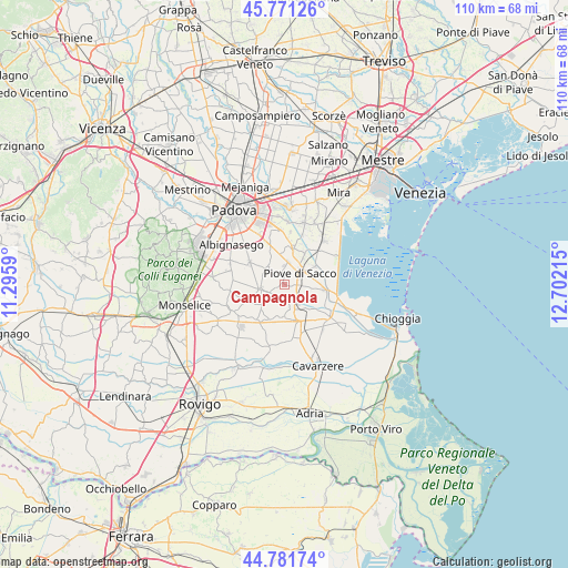
Campagnola GPS coordinates[2]
45° 16' 43.176" North, 11° 59' 56.472" East
| Map corner | latitude | longitude |
|---|---|---|
| Upper-left | 45.77126°, | 11.2959° |
| Center: | 45.27866°, | 11.99902° |
| Lower-right: | 44.78174°, | 12.70215° |
| Map W x H: | 110×110 km | = 68.4×68.4mi |
| max Lat: | 47.04031° ⇑33.1% North |
| Campagnola: | 45.27866° |
| min Lat: | ⇓66.9% South 35.50142° |
| min Long | Campagnola | max Long |
| 6.69888° | 11.99902° | 18.48682° |
| W 55.8%⇐ | ⇒44.2% E |
Elevation
Elevation of Campagnola is 5 m = 16 ft, and this is 301.7 m = 990 ft below average elevation for this country.
| Max E: |
2085 m = 6841 ft | 97.2% |
| Avg. | 306.7 m = 1006 ft | |
| Campagnola | 5 m = 16 ft | |
Min E: |
-4 m = -13 ft | 2.8% |
See also: Italy elevation on elevation.city.
Geographical zone
Campagnola is located in North temperate zone (between Tropic of Cancer and the Arctic Circle). Distance of this North polar circle is 2366.7 km =1470.6 mi to North.| Distance of | km | miles | from Campagnola |
|---|---|---|---|
| North Pole | 4972.5 | 3089.8 | to North |
| Arctic Circle | 2366.7 | 1470.6 | to North |
| Tropic Cancer | 2428.6 | 1509.1 | to South |
| Equator | 5034.5 | 3128.3 | to South |


Nearby cities:
15 places around Campagnola: (largest is in red/bold)
• Arzercavalli
6 km =3.7 mi,  230°
230°
• Arzerello
2.1 km =1.3 mi,  104°
104°
• Arzergrande
3.9 km =2.4 mi, 99°
• Bovolenta
5.1 km =3.2 mi,  257°
257°
• Brugine
2.1 km =1.3 mi,  344°
344°
• Cambroso
6.7 km =4.2 mi,  82°
82°
• Campolongo Maggiore
6.1 km =3.8 mi,  35°
35°
• Campolongo Maggiore Liettoli
7 km =4.3 mi,  16°
16°
• Candiana
6.3 km =3.9 mi,  184°
184°
• Corte
6.6 km =4.1 mi,  59°
59°
• Piove di Sacco-Piovega
3.6 km =2.2 mi, 55°
• Polverara
4.9 km =3 mi,  314°
314°
• Pontelongo
4.2 km =2.6 mi,  150°
150°
• Sant'Angelo di Piove di Sacco
4.4 km =2.7 mi,  10°
10°
• Vallonga
6.3 km =3.9 mi, 96°
Sources, notices
• [Note1] Compared only with cities in Italy existing in our database
• [Src1] Map data: © OpenStreetMap contributors (CC-BY-SA)
• [Src2] Other city data from geonames.org with taken over terms of usage.
• [Src3] Geographical zone / Annual Mean Temperature by Robert A. Rohde @ Wikipedia
