Campeglio geodata
Campeglio (Friuli Venezia Giulia) is a populated place; located in Italy in Europe/Rome (GMT+2) time zone. With population of 682 people, there are 8413 cities with bigger population in this country. Compared to other cities in Italy, 94.5% of cities are located further ↓South; 72.1% of cities are located further ←West and 63.1% of cities have higher elevation than Campeglio. Note1
Administrative division(s):
- Level 1: Friuli Venezia Giulia
- Level 2: Provincia di Udine
- Level 3: Faedis


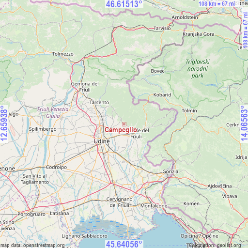
Campeglio GPS coordinates[2]
46° 7' 48" North, 13° 21' 45" East
| Map corner | latitude | longitude |
|---|---|---|
| Upper-left | 46.61513°, | 12.65938° |
| Center: | 46.13°, | 13.3625° |
| Lower-right: | 45.64056°, | 14.06563° |
| Map W x H: | 108.4×108.4 km | = 67.4×67.4mi |
| max Lat: | 47.04031° ⇑5.5% North |
| Campeglio: | 46.13° |
| min Lat: | ⇓94.5% South 35.50142° |
| min Long | Campeglio | max Long |
| 6.69888° | 13.3625° | 18.48682° |
| W 72.1%⇐ | ⇒27.9% E |
Elevation
Elevation of Campeglio is 140 m = 459 ft, and this is 166.7 m = 547 ft below average elevation for this country.
| Max E: |
2085 m = 6841 ft | 63.1% |
| Avg. | 306.7 m = 1006 ft | |
| Campeglio | 140 m = 459 ft | |
Min E: |
-4 m = -13 ft | 36.9% |
See also: Italy elevation on elevation.city.
Geographical zone
Campeglio is located in North temperate zone (between Tropic of Cancer and the Arctic Circle). Distance of this North polar circle is 2272 km =1411.8 mi to North.| Distance of | km | miles | from Campeglio |
|---|---|---|---|
| North Pole | 4877.9 | 3031 | to North |
| Arctic Circle | 2272 | 1411.8 | to North |
| Tropic Cancer | 2523.3 | 1567.9 | to South |
| Equator | 5129.2 | 3187.1 | to South |


Nearby cities:
15 places around Campeglio: (largest is in red/bold)
• Attimis
7.8 km =4.8 mi,  329°
329°
• Cividale del Friuli
6.8 km =4.2 mi,  130°
130°
• Faedis
2.6 km =1.6 mi, 327°
• Moimacco
4.4 km =2.7 mi,  169°
169°
• Orzano
7.2 km =4.5 mi,  190°
190°
• Povoletto
5.7 km =3.5 mi,  253°
253°
• Premariacco
8 km =5 mi,  162°
162°
• Primulacco
6.9 km =4.3 mi,  283°
283°
• Ravosa-Magredis
5.3 km =3.3 mi,  297°
297°
• Reana del Rojale
9.1 km =5.7 mi, 279°
• Remanzacco
5.8 km =3.6 mi,  211°
211°
• San Pietro al Natisone
9.4 km =5.8 mi,  100°
100°
• Savorgnano del Torre
8 km =5 mi, 299°
• Torreano
5.2 km =3.2 mi,  92°
92°
• Ziracco
2.5 km =1.6 mi,  216°
216°
Sources, notices
• [Note1] Compared only with cities in Italy existing in our database
• [Src1] Map data: © OpenStreetMap contributors (CC-BY-SA)
• [Src2] Other city data from geonames.org with taken over terms of usage.
• [Src3] Geographical zone / Annual Mean Temperature by Robert A. Rohde @ Wikipedia
