Premariacco geodata
Premariacco (Friuli Venezia Giulia) is a seat of a third-order administrative division; located in Italy in Europe/Rome (GMT+2) time zone. With population of 1,743 people, there are 4585 cities with bigger population in this country. Compared to other cities in Italy, 93.3% of cities are located further ↓South; 72.3% of cities are located further ←West and 67.4% of cities have higher elevation than Premariacco. Note1
Administrative division(s):
- Level 1: Friuli Venezia Giulia
- Level 2: Provincia di Udine
- Level 3: Premariacco


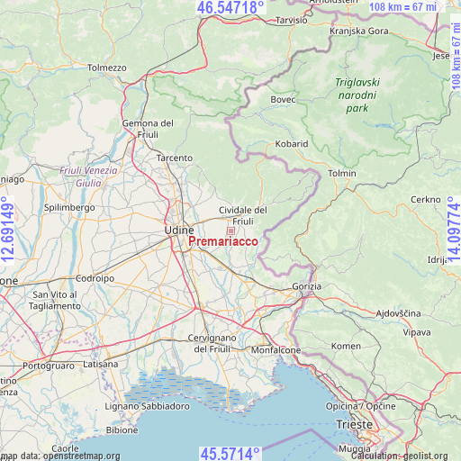
Premariacco GPS coordinates[2]
46° 3' 41.22" North, 13° 23' 40.596" East
| Map corner | latitude | longitude |
|---|---|---|
| Upper-left | 46.54718°, | 12.69149° |
| Center: | 46.06145°, | 13.39461° |
| Lower-right: | 45.5714°, | 14.09774° |
| Map W x H: | 108.5×108.5 km | = 67.4×67.4mi |
| max Lat: | 47.04031° ⇑6.7% North |
| Premariacco: | 46.06145° |
| min Lat: | ⇓93.3% South 35.50142° |
| min Long | Premariacco | max Long |
| 6.69888° | 13.39461° | 18.48682° |
| W 72.3%⇐ | ⇒27.7% E |
Elevation
Elevation of Premariacco is 113 m = 371 ft, and this is 193.7 m = 635 ft below average elevation for this country.
| Max E: |
2085 m = 6841 ft | 67.4% |
| Avg. | 306.7 m = 1006 ft | |
| Premariacco | 113 m = 371 ft | |
Min E: |
-4 m = -13 ft | 32.6% |
See also: Italy elevation on elevation.city.
Geographical zone
Premariacco is located in North temperate zone (between Tropic of Cancer and the Arctic Circle). Distance of this North polar circle is 2279.6 km =1416.5 mi to North.| Distance of | km | miles | from Premariacco |
|---|---|---|---|
| North Pole | 4885.5 | 3035.7 | to North |
| Arctic Circle | 2279.6 | 1416.5 | to North |
| Tropic Cancer | 2515.6 | 1563.1 | to South |
| Equator | 5121.6 | 3182.4 | to South |


Nearby cities:
15 places around Premariacco: (largest is in red/bold)
• Buttrio
7.3 km =4.5 mi,  220°
220°
• Campeglio
8 km =5 mi,  342°
342°
• Cerneglons
6.6 km =4.1 mi,  261°
261°
• Cividale del Friuli
4.1 km =2.5 mi,  39°
39°
• Dolegna del Collio
7.3 km =4.5 mi,  117°
117°
• Ipplis
2.4 km =1.5 mi,  149°
149°
• Manzano
8.2 km =5.1 mi,  189°
189°
• Moimacco
3.7 km =2.3 mi,  333°
333°
• Orsaria
2.7 km =1.7 mi,  200°
200°
• Orzano
3.9 km =2.4 mi,  278°
278°
• Pradamano
7.8 km =4.8 mi,  246°
246°
• Prepotto
6.8 km =4.2 mi,  105°
105°
• Remanzacco
6.1 km =3.8 mi,  295°
295°
• Torreano
7.9 km =4.9 mi,  19°
19°
• Ziracco
6.9 km =4.3 mi,  324°
324°
Sources, notices
• [Note1] Compared only with cities in Italy existing in our database
• [Src1] Map data: © OpenStreetMap contributors (CC-BY-SA)
• [Src2] Other city data from geonames.org with taken over terms of usage.
• [Src3] Geographical zone / Annual Mean Temperature by Robert A. Rohde @ Wikipedia
