Casagiove geodata
Casagiove (Campania) is a seat of a third-order administrative division; located in Italy in Europe/Rome (GMT+2) time zone. With population of 13,654 people, there are 667 cities with bigger population in this country. Compared to other cities in Italy, 77.8% of cities are located further ↑North; 81% of cities are located further ←West and 78.3% of cities have higher elevation than Casagiove. Note1


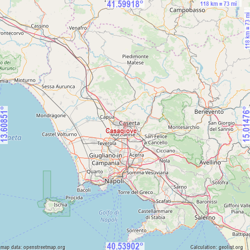
Casagiove GPS coordinates[2]
41° 4' 16.464" North, 14° 18' 41.868" East
| Map corner | latitude | longitude |
|---|---|---|
| Upper-left | 41.59918°, | 13.60851° |
| Center: | 41.07124°, | 14.31163° |
| Lower-right: | 40.53902°, | 15.01476° |
| Map W x H: | 117.9×117.9 km | = 73.3×73.3mi |
| max Lat: | 47.04031° ⇑77.8% North |
| Casagiove: | 41.07124° |
| min Lat: | ⇓22.2% South 35.50142° |
| min Long | Casagiove | max Long |
| 6.69888° | 14.31163° | 18.48682° |
| W 81%⇐ | ⇒19% E |
Elevation
Elevation of Casagiove is 58 m = 190 ft, and this is 248.7 m = 816 ft below average elevation for this country.
| Max E: |
2085 m = 6841 ft | 78.3% |
| Avg. | 306.7 m = 1006 ft | |
| Casagiove | 58 m = 190 ft | |
Min E: |
-4 m = -13 ft | 21.7% |
See also: Italy elevation on elevation.city.
Geographical zone
Casagiove is located in North temperate zone (between Tropic of Cancer and the Arctic Circle). Distance of this Northern Tropic circle is 1960.8 km =1218.4 mi to South.| Distance of | km | miles | from Casagiove |
|---|---|---|---|
| North Pole | 5440.4 | 3380.5 | to North |
| Arctic Circle | 2834.5 | 1761.3 | to North |
| Tropic Cancer | 1960.8 | 1218.4 | to South |
| Equator | 4566.7 | 2837.6 | to South |


Nearby cities:
15 places around Casagiove: (largest is in red/bold)
• Capodrise
3.2 km =2 mi,  188°
188°
• Casapulla
2 km =1.2 mi,  287°
287°
• Caserta
1.7 km =1.1 mi,  84°
84°
• Casola
6.4 km =4 mi,  65°
65°
• Castel Morrone
6.6 km =4.1 mi,  33°
33°
• Curti
2.7 km =1.7 mi,  281°
281°
• Macerata Campania
3 km =1.9 mi,  252°
252°
• Marcianise
4.6 km =2.9 mi, 193°
• Portico di Caserta
3.2 km =2 mi,  236°
236°
• Recale
1.7 km =1.1 mi,  205°
205°
• San Marco Evangelista
4.5 km =2.8 mi,  148°
148°
• San Nicola la Strada
2.8 km =1.7 mi,  139°
139°
• San Prisco
3.3 km =2.1 mi,  299°
299°
• San Tammaro
6.8 km =4.2 mi,  274°
274°
• Santa Maria Capua Vetere
5 km =3.1 mi, 283°
Sources, notices
• [Note1] Compared only with cities in Italy existing in our database
• [Src1] Map data: © OpenStreetMap contributors (CC-BY-SA)
• [Src2] Other city data from geonames.org with taken over terms of usage.
• [Src3] Geographical zone / Annual Mean Temperature by Robert A. Rohde @ Wikipedia
