Casola geodata
Casola (Campania) is a populated place; located in Italy in Europe/Rome (GMT+2) time zone. With population of 1,649 people, there are 4784 cities with bigger population in this country. Compared to other cities in Italy, 77.5% of cities are located further ↑North; 81.6% of cities are located further ←West and 64.7% of cities have lower elevation than Casola. Note1


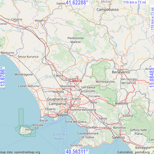
Casola GPS coordinates[2]
41° 5' 42.468" North, 14° 22' 54.192" East
| Map corner | latitude | longitude |
|---|---|---|
| Upper-left | 41.62288°, | 13.6786° |
| Center: | 41.09513°, | 14.38172° |
| Lower-right: | 40.56311°, | 15.08485° |
| Map W x H: | 117.8×117.8 km | = 73.2×73.2mi |
| max Lat: | 47.04031° ⇑77.5% North |
| Casola: | 41.09513° |
| min Lat: | ⇓22.5% South 35.50142° |
| min Long | Casola | max Long |
| 6.69888° | 14.38172° | 18.48682° |
| W 81.6%⇐ | ⇒18.4% E |
Elevation
Elevation of Casola is 340 m = 1115 ft, and this is 33.3 m = 109 ft above average elevation for this country.
| Max E: |
2085 m = 6841 ft | 35.3% |
| Casola | 340 m 1115 ft | |
| Avg. | 306.7 m = 1006 ft | |
Min E: |
-4 m = -13 ft | 64.7% |
See also: Italy elevation on elevation.city.
Geographical zone
Casola is located in North temperate zone (between Tropic of Cancer and the Arctic Circle). Distance of this Northern Tropic circle is 1963.4 km =1220 mi to South.| Distance of | km | miles | from Casola |
|---|---|---|---|
| North Pole | 5437.7 | 3378.8 | to North |
| Arctic Circle | 2831.8 | 1759.6 | to North |
| Tropic Cancer | 1963.4 | 1220 | to South |
| Equator | 4569.4 | 2839.3 | to South |


Nearby cities:
15 places around Casola: (largest is in red/bold)
• Annunziata
3.2 km =2 mi,  334°
334°
• Bagnoli
5.1 km =3.2 mi,  105°
105°
• Casagiove
6.4 km =4 mi,  245°
245°
• Caserta
4.8 km =3 mi,  238°
238°
• Castel Morrone
3.7 km =2.3 mi,  321°
321°
• Cervino
7.1 km =4.4 mi,  149°
149°
• Dugenta
7.5 km =4.7 mi,  53°
53°
• Durazzano
6.7 km =4.2 mi,  122°
122°
• Giardoni
4.8 km =3 mi,  56°
56°
• Limatola
5.1 km =3.2 mi,  11°
11°
• Maddaloni
6.6 km =4.1 mi,  179°
179°
• Recale
7.9 km =4.9 mi, 237°
• San Marco Evangelista
7.4 km =4.6 mi,  208°
208°
• San Nicola la Strada
6.2 km =3.9 mi,  220°
220°
• Valle di Maddaloni
3.5 km =2.2 mi, 119°
Sources, notices
• [Note1] Compared only with cities in Italy existing in our database
• [Src1] Map data: © OpenStreetMap contributors (CC-BY-SA)
• [Src2] Other city data from geonames.org with taken over terms of usage.
• [Src3] Geographical zone / Annual Mean Temperature by Robert A. Rohde @ Wikipedia
