Castel Morrone geodata
Castel Morrone (Campania) is a seat of a third-order administrative division; located in Italy in Europe/Rome (GMT+2) time zone. With population of 3,988 people, there are 2402 cities with bigger population in this country. Compared to other cities in Italy, 77.4% of cities are located further ↑North; 81.3% of cities are located further ←West and 50.8% of cities have higher elevation than Castel Morrone. Note1


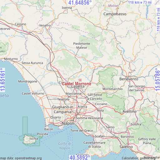
Castel Morrone GPS coordinates[2]
41° 7' 15.672" North, 14° 21' 17.028" East
| Map corner | latitude | longitude |
|---|---|---|
| Upper-left | 41.64856°, | 13.65161° |
| Center: | 41.12102°, | 14.35473° |
| Lower-right: | 40.5892°, | 15.05786° |
| Map W x H: | 117.8×117.8 km | = 73.2×73.2mi |
| max Lat: | 47.04031° ⇑77.4% North |
| Castel Morrone: | 41.12102° |
| min Lat: | ⇓22.6% South 35.50142° |
| min Long | Castel Morrone | max Long |
| 6.69888° | 14.35473° | 18.48682° |
| W 81.3%⇐ | ⇒18.7% E |
Elevation
Elevation of Castel Morrone is 230 m = 755 ft, and this is 76.7 m = 252 ft below average elevation for this country.
| Max E: |
2085 m = 6841 ft | 50.8% |
| Avg. | 306.7 m = 1006 ft | |
| Castel Morrone | 230 m = 755 ft | |
Min E: |
-4 m = -13 ft | 49.2% |
See also: Italy elevation on elevation.city.
Geographical zone
Castel Morrone is located in North temperate zone (between Tropic of Cancer and the Arctic Circle). Distance of this Northern Tropic circle is 1966.3 km =1221.8 mi to South.| Distance of | km | miles | from Castel Morrone |
|---|---|---|---|
| North Pole | 5434.8 | 3377 | to North |
| Arctic Circle | 2828.9 | 1757.8 | to North |
| Tropic Cancer | 1966.3 | 1221.8 | to South |
| Equator | 4572.2 | 2841 | to South |


Nearby cities:
15 places around Castel Morrone: (largest is in red/bold)
• Annunziata
0.9 km =0.6 mi,  90°
90°
• Bagnoli
8.3 km =5.2 mi,  120°
120°
• Caiazzo
7.1 km =4.4 mi,  3°
3°
• Casagiove
6.6 km =4.1 mi,  213°
213°
• Casapulla
7.4 km =4.6 mi,  228°
228°
• Caserta
5.7 km =3.5 mi,  199°
199°
• Casola
3.7 km =2.3 mi,  141°
141°
• Curti
8 km =5 mi, 231°
• Giardoni
6.2 km =3.9 mi, 92°
• Limatola
3.9 km =2.4 mi,  57°
57°
• Piana di Monte Verna
5.4 km =3.4 mi,  341°
341°
• San Giovanni e Paolo
6.7 km =4.2 mi,  24°
24°
• San Nicola la Strada
7.8 km =4.8 mi,  193°
193°
• San Prisco
7.6 km =4.7 mi,  239°
239°
• Valle di Maddaloni
7 km =4.3 mi,  131°
131°
Sources, notices
• [Note1] Compared only with cities in Italy existing in our database
• [Src1] Map data: © OpenStreetMap contributors (CC-BY-SA)
• [Src2] Other city data from geonames.org with taken over terms of usage.
• [Src3] Geographical zone / Annual Mean Temperature by Robert A. Rohde @ Wikipedia
