Caserta geodata
Caserta (Campania) is a seat of a second-order administrative division; located in Italy in Europe/Rome (GMT+2) time zone. With population of 72,844 people, there are 68 cities with bigger population in this country. Compared to other cities in Italy, 77.8% of cities are located further ↑North; 81.1% of cities are located further ←West and 75.4% of cities have higher elevation than Caserta. Note1


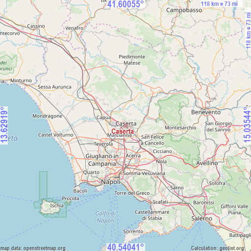
Caserta GPS coordinates[2]
41° 4' 21.432" North, 14° 19' 56.316" East
| Map corner | latitude | longitude |
|---|---|---|
| Upper-left | 41.60055°, | 13.62919° |
| Center: | 41.07262°, | 14.33231° |
| Lower-right: | 40.54041°, | 15.03544° |
| Map W x H: | 117.9×117.9 km | = 73.3×73.3mi |
| max Lat: | 47.04031° ⇑77.8% North |
| Caserta: | 41.07262° |
| min Lat: | ⇓22.2% South 35.50142° |
| min Long | Caserta | max Long |
| 6.69888° | 14.33231° | 18.48682° |
| W 81.1%⇐ | ⇒18.9% E |
Elevation
Elevation of Caserta is 72 m = 236 ft, and this is 234.7 m = 770 ft below average elevation for this country.
| Max E: |
2085 m = 6841 ft | 75.4% |
| Avg. | 306.7 m = 1006 ft | |
| Caserta | 72 m = 236 ft | |
Min E: |
-4 m = -13 ft | 24.6% |
See also: Caserta elevation on elevation.city.
Geographical zone
Caserta is located in North temperate zone (between Tropic of Cancer and the Arctic Circle). Distance of this Northern Tropic circle is 1960.9 km =1218.4 mi to South.| Distance of | km | miles | from Caserta |
|---|---|---|---|
| North Pole | 5440.2 | 3380.4 | to North |
| Arctic Circle | 2834.3 | 1761.2 | to North |
| Tropic Cancer | 1960.9 | 1218.4 | to South |
| Equator | 4566.8 | 2837.7 | to South |


Nearby cities:
15 places around Caserta: (largest is in red/bold)
• Annunziata
6 km =3.7 mi,  27°
27°
• Capodrise
4 km =2.5 mi,  213°
213°
• Casagiove
1.7 km =1.1 mi,  264°
264°
• Casapulla
3.6 km =2.2 mi,  277°
277°
• Casola
4.8 km =3 mi,  58°
58°
• Castel Morrone
5.7 km =3.5 mi,  19°
19°
• Curti
4.4 km =2.7 mi, 275°
• Macerata Campania
4.7 km =2.9 mi, 257°
• Maddaloni
5.9 km =3.7 mi,  134°
134°
• Marcianise
5.5 km =3.4 mi, 211°
• Portico di Caserta
4.8 km =3 mi,  246°
246°
• Recale
3 km =1.9 mi,  235°
235°
• San Marco Evangelista
4 km =2.5 mi,  170°
170°
• San Nicola la Strada
2.3 km =1.4 mi,  177°
177°
• San Prisco
4.9 km =3 mi,  287°
287°
Sources, notices
• [Note1] Compared only with cities in Italy existing in our database
• [Src1] Map data: © OpenStreetMap contributors (CC-BY-SA)
• [Src2] Other city data from geonames.org with taken over terms of usage.
• [Src3] Geographical zone / Annual Mean Temperature by Robert A. Rohde @ Wikipedia
