Ferrere geodata
Ferrere (Piedmont) is a seat of a third-order administrative division; located in Italy in Europe/Rome (GMT+2) time zone. With population of 507 people, there are 9858 cities with bigger population in this country. Compared to other cities in Italy, 57.5% of cities are located further ↓South; 93.7% of cities are located further →East and 50.4% of cities have lower elevation than Ferrere. Note1


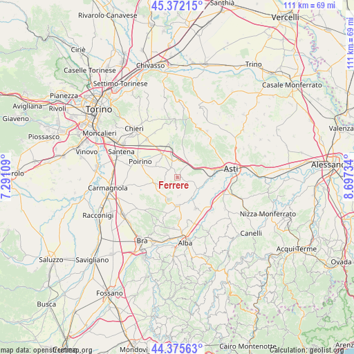
Ferrere GPS coordinates[2]
44° 52' 33.78" North, 7° 59' 39.156" East
| Map corner | latitude | longitude |
|---|---|---|
| Upper-left | 45.37215°, | 7.29109° |
| Center: | 44.87605°, | 7.99421° |
| Lower-right: | 44.37563°, | 8.69734° |
| Map W x H: | 110.8×110.8 km | = 68.8×68.8mi |
| max Lat: | 47.04031° ⇑42.5% North |
| Ferrere: | 44.87605° |
| min Lat: | ⇓57.5% South 35.50142° |
| min Long | Ferrere | max Long |
| 6.69888° | 7.99421° | 18.48682° |
| W 6.3%⇐ | ⇒93.7% E |
Elevation
Elevation of Ferrere is 237 m = 778 ft, and this is 69.7 m = 229 ft below average elevation for this country.
| Max E: |
2085 m = 6841 ft | 49.6% |
| Avg. | 306.7 m = 1006 ft | |
| Ferrere | 237 m = 778 ft | |
Min E: |
-4 m = -13 ft | 50.4% |
See also: Italy elevation on elevation.city.
Geographical zone
Ferrere is located in North temperate zone (between Tropic of Cancer and the Arctic Circle). Distance of this Northern Tropic circle is 2383.8 km =1481.2 mi to South.| Distance of | km | miles | from Ferrere |
|---|---|---|---|
| North Pole | 5017.3 | 3117.6 | to North |
| Arctic Circle | 2411.4 | 1498.4 | to North |
| Tropic Cancer | 2383.8 | 1481.2 | to South |
| Equator | 4989.7 | 3100.5 | to South |


Nearby cities:
15 places around Ferrere: (largest is in red/bold)
• Baldichieri d'Asti
8.4 km =5.2 mi,  66°
66°
• Cantarana
3.9 km =2.4 mi,  41°
41°
• Castellero
8.3 km =5.2 mi,  48°
48°
• Cellarengo
4.1 km =2.5 mi,  251°
251°
• Cisterna d'Asti
5.7 km =3.5 mi,  174°
174°
• Dusino
5.8 km =3.6 mi,  342°
342°
• Isolabella
7.5 km =4.7 mi,  296°
296°
• Maretto
8.3 km =5.2 mi,  22°
22°
• Montà
7.5 km =4.7 mi,  204°
204°
• Pralormo
7.3 km =4.5 mi,  255°
255°
• San Damiano d'Asti
7.2 km =4.5 mi,  130°
130°
• San Paolo Solbrito
8.5 km =5.3 mi,  347°
347°
• Tigliole
6.6 km =4.1 mi,  80°
80°
• Valfenera
3.7 km =2.3 mi,  320°
320°
• Villafranca d'Asti
5.1 km =3.2 mi,  30°
30°
Sources, notices
• [Note1] Compared only with cities in Italy existing in our database
• [Src1] Map data: © OpenStreetMap contributors (CC-BY-SA)
• [Src2] Other city data from geonames.org with taken over terms of usage.
• [Src3] Geographical zone / Annual Mean Temperature by Robert A. Rohde @ Wikipedia
