Pralormo geodata
Pralormo (Piedmont) is a seat of a third-order administrative division; located in Italy in Europe/Rome (GMT+2) time zone. With population of 897 people, there are 7170 cities with bigger population in this country. Compared to other cities in Italy, 57.2% of cities are located further ↓South; 94.6% of cities are located further →East and 61.2% of cities have lower elevation than Pralormo. Note1


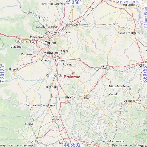
Pralormo GPS coordinates[2]
44° 51' 35.136" North, 7° 54' 15.84" East
| Map corner | latitude | longitude |
|---|---|---|
| Upper-left | 45.356°, | 7.20128° |
| Center: | 44.85976°, | 7.9044° |
| Lower-right: | 44.3592°, | 8.60753° |
| Map W x H: | 110.8×110.8 km | = 68.8×68.8mi |
| max Lat: | 47.04031° ⇑42.8% North |
| Pralormo: | 44.85976° |
| min Lat: | ⇓57.2% South 35.50142° |
| min Long | Pralormo | max Long |
| 6.69888° | 7.9044° | 18.48682° |
| W 5.4%⇐ | ⇒94.6% E |
Elevation
Elevation of Pralormo is 308 m = 1010 ft, and this is 1.3 m = 4 ft above average elevation for this country.
| Max E: |
2085 m = 6841 ft | 38.8% |
| Pralormo | 308 m 1010 ft | |
| Avg. | 306.7 m = 1006 ft | |
Min E: |
-4 m = -13 ft | 61.2% |
See also: Italy elevation on elevation.city.
Geographical zone
Pralormo is located in North temperate zone (between Tropic of Cancer and the Arctic Circle). Distance of this Northern Tropic circle is 2382 km =1480.1 mi to South.| Distance of | km | miles | from Pralormo |
|---|---|---|---|
| North Pole | 5019.1 | 3118.7 | to North |
| Arctic Circle | 2413.2 | 1499.5 | to North |
| Tropic Cancer | 2382 | 1480.1 | to South |
| Equator | 4987.9 | 3099.3 | to South |


Nearby cities:
15 places around Pralormo: (largest is in red/bold)
• Canale
10 km =6.2 mi,  135°
135°
• Cellarengo
3.3 km =2.1 mi,  81°
81°
• Ceresole Alba
9.3 km =5.8 mi,  224°
224°
• Cisterna d'Asti
8.5 km =5.3 mi,  116°
116°
• Dusino
9 km =5.6 mi,  35°
35°
• Favari-Avatanei
10.1 km =6.3 mi,  305°
305°
• Ferrere
7.3 km =4.5 mi, 75°
• Isolabella
5.2 km =3.2 mi,  4°
4°
• Montaldo Roero
10.3 km =6.4 mi,  170°
170°
• Monteu Roero
9.1 km =5.7 mi, 165°
• Montà
6.4 km =4 mi, 141°
• Poirino
8.2 km =5.1 mi,  325°
325°
• Santo Stefano Roero
8.4 km =5.2 mi,  160°
160°
• Valfenera
6.6 km =4.1 mi,  45°
45°
• Villanova d'Asti
9.6 km =6 mi,  15°
15°
Sources, notices
• [Note1] Compared only with cities in Italy existing in our database
• [Src1] Map data: © OpenStreetMap contributors (CC-BY-SA)
• [Src2] Other city data from geonames.org with taken over terms of usage.
• [Src3] Geographical zone / Annual Mean Temperature by Robert A. Rohde @ Wikipedia
