Cosseria geodata
Cosseria (Liguria) is a seat of a third-order administrative division; located in Italy in Europe/Rome (GMT+2) time zone. With population of 278 people, there are 10762 cities with bigger population in this country. Compared to other cities in Italy, 50.9% of cities are located further ↑North; 90.7% of cities are located further →East and 80.4% of cities have lower elevation than Cosseria. Note1


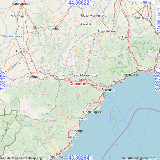
Cosseria GPS coordinates[2]
44° 22' 3.864" North, 8° 14' 5.46" East
| Map corner | latitude | longitude |
|---|---|---|
| Upper-left | 44.86822°, | 7.53173° |
| Center: | 44.36774°, | 8.23485° |
| Lower-right: | 43.86294°, | 8.93798° |
| Map W x H: | 111.8×111.8 km | = 69.5×69.5mi |
| max Lat: | 47.04031° ⇑50.9% North |
| Cosseria: | 44.36774° |
| min Lat: | ⇓49.1% South 35.50142° |
| min Long | Cosseria | max Long |
| 6.69888° | 8.23485° | 18.48682° |
| W 9.3%⇐ | ⇒90.7% E |
Elevation
Elevation of Cosseria is 530 m = 1739 ft, and this is 223.3 m = 733 ft above average elevation for this country.
| Max E: |
2085 m = 6841 ft | 19.6% |
| Cosseria | 530 m 1739 ft | |
| Avg. | 306.7 m = 1006 ft | |
Min E: |
-4 m = -13 ft | 80.4% |
See also: Italy elevation on elevation.city.
Geographical zone
Cosseria is located in North temperate zone (between Tropic of Cancer and the Arctic Circle). Distance of this Northern Tropic circle is 2327.3 km =1446.1 mi to South.| Distance of | km | miles | from Cosseria |
|---|---|---|---|
| North Pole | 5073.8 | 3152.7 | to North |
| Arctic Circle | 2467.9 | 1533.5 | to North |
| Tropic Cancer | 2327.3 | 1446.1 | to South |
| Equator | 4933.2 | 3065.3 | to South |


Nearby cities:
15 places around Cosseria: (largest is in red/bold)
• Bormida-Genepro
3.8 km =2.4 mi,  312°
312°
• Cairo Montenotte
4.8 km =3 mi,  45°
45°
• Carcare
4.6 km =2.9 mi,  108°
108°
• Cengio Alto
3.5 km =2.2 mi,  302°
302°
• Ferrania
6.8 km =4.2 mi,  98°
98°
• Millesimo
2.5 km =1.6 mi,  267°
267°
• Montezemolo
7.5 km =4.7 mi,  277°
277°
• Murialdo
7.7 km =4.8 mi,  223°
223°
• Pallare
5.7 km =3.5 mi,  141°
141°
• Piano
7.9 km =4.9 mi, 223°
• Plodio
1.8 km =1.1 mi,  147°
147°
• Roccavignale
3.6 km =2.2 mi,  258°
258°
• Rocchetta Cairo
8.6 km =5.3 mi,  37°
37°
• Saliceto
7.3 km =4.5 mi, 313°
• Valzemola
4.9 km =3 mi, 265°
Sources, notices
• [Note1] Compared only with cities in Italy existing in our database
• [Src1] Map data: © OpenStreetMap contributors (CC-BY-SA)
• [Src2] Other city data from geonames.org with taken over terms of usage.
• [Src3] Geographical zone / Annual Mean Temperature by Robert A. Rohde @ Wikipedia
