Bormida-Genepro geodata
Bormida-Genepro (Liguria) is a seat of a third-order administrative division; located in Italy in Europe/Rome (GMT+2) time zone. With population of 3,407 people, there are 2751 cities with bigger population in this country. Compared to other cities in Italy, 50.6% of cities are located further ↑North; 91.1% of cities are located further →East and 71.3% of cities have lower elevation than Bormida-Genepro. Note1


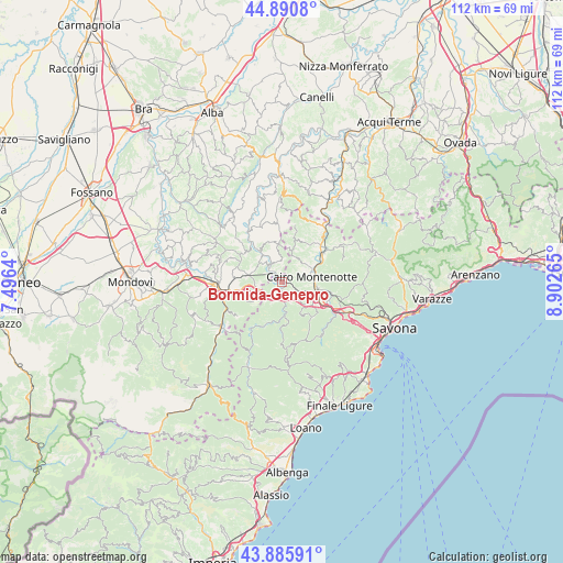
Bormida-Genepro GPS coordinates[2]
44° 23' 25.836" North, 8° 11' 58.272" East
| Map corner | latitude | longitude |
|---|---|---|
| Upper-left | 44.8908°, | 7.4964° |
| Center: | 44.39051°, | 8.19952° |
| Lower-right: | 43.88591°, | 8.90265° |
| Map W x H: | 111.7×111.7 km | = 69.4×69.4mi |
| max Lat: | 47.04031° ⇑50.6% North |
| Bormida-Genepro: | 44.39051° |
| min Lat: | ⇓49.4% South 35.50142° |
| min Long | Bormida-Genepro | max Long |
| 6.69888° | 8.19952° | 18.48682° |
| W 8.9%⇐ | ⇒91.1% E |
Elevation
Elevation of Bormida-Genepro is 407 m = 1335 ft, and this is 100.3 m = 329 ft above average elevation for this country.
| Max E: |
2085 m = 6841 ft | 28.7% |
| Bormida-Genepro | 407 m 1335 ft | |
| Avg. | 306.7 m = 1006 ft | |
Min E: |
-4 m = -13 ft | 71.3% |
See also: Italy elevation on elevation.city.
Geographical zone
Bormida-Genepro is located in North temperate zone (between Tropic of Cancer and the Arctic Circle). Distance of this Northern Tropic circle is 2329.8 km =1447.7 mi to South.| Distance of | km | miles | from Bormida-Genepro |
|---|---|---|---|
| North Pole | 5071.3 | 3151.2 | to North |
| Arctic Circle | 2465.4 | 1531.9 | to North |
| Tropic Cancer | 2329.8 | 1447.7 | to South |
| Equator | 4935.8 | 3067 | to South |


Nearby cities:
15 places around Bormida-Genepro: (largest is in red/bold)
• Cairo Montenotte
6.3 km =3.9 mi,  82°
82°
• Camerana
5.9 km =3.7 mi,  308°
308°
• Carcare
8.2 km =5.1 mi,  118°
118°
• Castelnuovo di Ceva
6.9 km =4.3 mi,  233°
233°
• Cengio Alto
0.7 km =0.4 mi,  192°
192°
• Cosseria
3.8 km =2.4 mi,  132°
132°
• Gottasecca
8.1 km =5 mi,  341°
341°
• Millesimo
2.6 km =1.6 mi,  173°
173°
• Montezemolo
4.9 km =3 mi,  252°
252°
• Murialdo
8.6 km =5.3 mi,  196°
196°
• Piano
8.6 km =5.3 mi, 197°
• Plodio
5.6 km =3.5 mi,  136°
136°
• Roccavignale
3.3 km =2.1 mi, 192°
• Saliceto
3.5 km =2.2 mi,  315°
315°
• Valzemola
3.6 km =2.2 mi,  214°
214°
Sources, notices
• [Note1] Compared only with cities in Italy existing in our database
• [Src1] Map data: © OpenStreetMap contributors (CC-BY-SA)
• [Src2] Other city data from geonames.org with taken over terms of usage.
• [Src3] Geographical zone / Annual Mean Temperature by Robert A. Rohde @ Wikipedia
