Moiola geodata
Moiola (Piedmont) is a seat of a third-order administrative division; located in Italy in Europe/Rome (GMT+2) time zone. With population of 216 people, there are 11051 cities with bigger population in this country. Compared to other cities in Italy, 51.6% of cities are located further ↑North; 98.4% of cities are located further →East and 88.9% of cities have lower elevation than Moiola. Note1


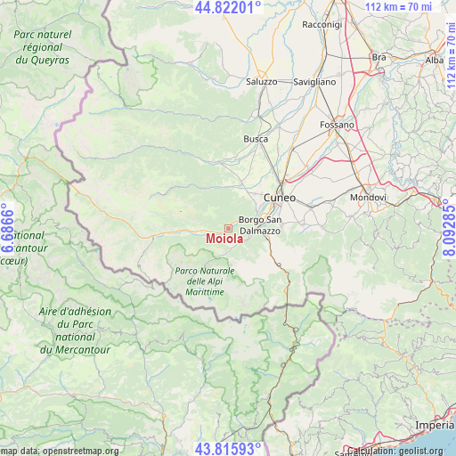
Moiola GPS coordinates[2]
44° 19' 16.068" North, 7° 23' 23.028" East
| Map corner | latitude | longitude |
|---|---|---|
| Upper-left | 44.82201°, | 6.6866° |
| Center: | 44.32113°, | 7.38973° |
| Lower-right: | 43.81593°, | 8.09285° |
| Map W x H: | 111.9×111.9 km | = 69.5×69.5mi |
| max Lat: | 47.04031° ⇑51.6% North |
| Moiola: | 44.32113° |
| min Lat: | ⇓48.4% South 35.50142° |
| min Long | Moiola | max Long |
| 6.69888° | 7.38973° | 18.48682° |
| W 1.6%⇐ | ⇒98.4% E |
Elevation
Elevation of Moiola is 691 m = 2267 ft, and this is 384.3 m = 1261 ft above average elevation for this country.
| Max E: |
2085 m = 6841 ft | 11.1% |
| Moiola | 691 m 2267 ft | |
| Avg. | 306.7 m = 1006 ft | |
Min E: |
-4 m = -13 ft | 88.9% |
See also: Italy elevation on elevation.city.
Geographical zone
Moiola is located in North temperate zone (between Tropic of Cancer and the Arctic Circle). Distance of this Northern Tropic circle is 2322.1 km =1442.9 mi to South.| Distance of | km | miles | from Moiola |
|---|---|---|---|
| North Pole | 5079 | 3155.9 | to North |
| Arctic Circle | 2473.1 | 1536.7 | to North |
| Tropic Cancer | 2322.1 | 1442.9 | to South |
| Equator | 4928 | 3062.1 | to South |


Nearby cities:
15 places around Moiola: (largest is in red/bold)
• Bernezzo
8 km =5 mi,  27°
27°
• Borgo San Dalmazzo
8.4 km =5.2 mi,  77°
77°
• Cervasca
9.3 km =5.8 mi,  44°
44°
• Demonte
7.3 km =4.5 mi,  265°
265°
• Entracque
9 km =5.6 mi,  175°
175°
• Gaiola
2.2 km =1.4 mi, 43°
• Rittana
3.4 km =2.1 mi,  11°
11°
• Roaschia
7.7 km =4.8 mi,  137°
137°
• Robilante
10.3 km =6.4 mi,  107°
107°
• Roccasparvera
4.7 km =2.9 mi,  60°
60°
• Roccavione
7.1 km =4.4 mi,  96°
96°
• Valdieri
4.9 km =3 mi,  172°
172°
• Valgrana
10.1 km =6.3 mi,  355°
355°
• Valloriate
2.2 km =1.4 mi,  325°
325°
• Vignolo
8.1 km =5 mi,  54°
54°
Sources, notices
• [Note1] Compared only with cities in Italy existing in our database
• [Src1] Map data: © OpenStreetMap contributors (CC-BY-SA)
• [Src2] Other city data from geonames.org with taken over terms of usage.
• [Src3] Geographical zone / Annual Mean Temperature by Robert A. Rohde @ Wikipedia
