Demonte geodata
Demonte (Piedmont) is a seat of a third-order administrative division; located in Italy in Europe/Rome (GMT+2) time zone. With population of 1,184 people, there are 6011 cities with bigger population in this country. Compared to other cities in Italy, 51.7% of cities are located further ↑North; 99% of cities are located further →East and 92% of cities have lower elevation than Demonte. Note1


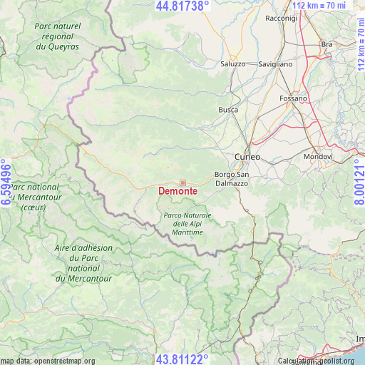
Demonte GPS coordinates[2]
44° 18' 59.256" North, 7° 17' 53.088" East
| Map corner | latitude | longitude |
|---|---|---|
| Upper-left | 44.81738°, | 6.59496° |
| Center: | 44.31646°, | 7.29808° |
| Lower-right: | 43.81122°, | 8.00121° |
| Map W x H: | 111.9×111.9 km | = 69.5×69.5mi |
| max Lat: | 47.04031° ⇑51.7% North |
| Demonte: | 44.31646° |
| min Lat: | ⇓48.3% South 35.50142° |
| min Long | Demonte | max Long |
| 6.69888° | 7.29808° | 18.48682° |
| W 1%⇐ | ⇒99% E |
Elevation
Elevation of Demonte is 769 m = 2523 ft, and this is 462.3 m = 1517 ft above average elevation for this country.
| Max E: |
2085 m = 6841 ft | 8% |
| Demonte | 769 m 2523 ft | |
| Avg. | 306.7 m = 1006 ft | |
Min E: |
-4 m = -13 ft | 92% |
See also: Italy elevation on elevation.city.
Geographical zone
Demonte is located in North temperate zone (between Tropic of Cancer and the Arctic Circle). Distance of this Northern Tropic circle is 2321.6 km =1442.6 mi to South.| Distance of | km | miles | from Demonte |
|---|---|---|---|
| North Pole | 5079.5 | 3156.3 | to North |
| Arctic Circle | 2473.6 | 1537 | to North |
| Tropic Cancer | 2321.6 | 1442.6 | to South |
| Equator | 4927.5 | 3061.8 | to South |


Nearby cities:
15 places around Demonte: (largest is in red/bold)
• Aisone
6.2 km =3.9 mi,  267°
267°
• Bernezzo
13.4 km =8.3 mi,  55°
55°
• Campomolino
12.3 km =7.6 mi,  326°
326°
• Entracque
11.6 km =7.2 mi,  136°
136°
• Gaiola
9.1 km =5.7 mi,  76°
76°
• Moiola
7.3 km =4.5 mi,  85°
85°
• Monterosso Grana
10.4 km =6.5 mi,  10°
10°
• Pradleves
11.4 km =7.1 mi,  353°
353°
• Rittana
8.9 km =5.5 mi, 64°
• Roaschia
13.6 km =8.5 mi,  112°
112°
• Roccasparvera
11.8 km =7.3 mi, 75°
• Valdieri
9 km =5.6 mi,  118°
118°
• Valgrana
12.5 km =7.8 mi,  31°
31°
• Valloriate
6.5 km =4 mi,  68°
68°
• Vinadio
9.7 km =6 mi,  264°
264°
Sources, notices
• [Note1] Compared only with cities in Italy existing in our database
• [Src1] Map data: © OpenStreetMap contributors (CC-BY-SA)
• [Src2] Other city data from geonames.org with taken over terms of usage.
• [Src3] Geographical zone / Annual Mean Temperature by Robert A. Rohde @ Wikipedia
