Beverino geodata
Beverino (Liguria) is a seat of a third-order administrative division; located in Italy in Europe/Rome (GMT+2) time zone. With population of 50 people, there are 11602 cities with bigger population in this country. Compared to other cities in Italy, 52.8% of cities are located further ↑North; 69.9% of cities are located further →East and 52.2% of cities have higher elevation than Beverino. Note1


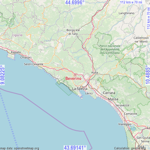
Beverino GPS coordinates[2]
44° 11' 51.576" North, 9° 47' 7.332" East
| Map corner | latitude | longitude |
|---|---|---|
| Upper-left | 44.6996°, | 9.08225° |
| Center: | 44.19766°, | 9.78537° |
| Lower-right: | 43.69141°, | 10.4885° |
| Map W x H: | 112.1×112.1 km | = 69.7×69.7mi |
| max Lat: | 47.04031° ⇑52.8% North |
| Beverino: | 44.19766° |
| min Lat: | ⇓47.2% South 35.50142° |
| min Long | Beverino | max Long |
| 6.69888° | 9.78537° | 18.48682° |
| W 30.1%⇐ | ⇒69.9% E |
Elevation
Elevation of Beverino is 221 m = 725 ft, and this is 85.7 m = 281 ft below average elevation for this country.
| Max E: |
2085 m = 6841 ft | 52.2% |
| Avg. | 306.7 m = 1006 ft | |
| Beverino | 221 m = 725 ft | |
Min E: |
-4 m = -13 ft | 47.8% |
See also: Italy elevation on elevation.city.
Geographical zone
Beverino is located in North temperate zone (between Tropic of Cancer and the Arctic Circle). Distance of this Northern Tropic circle is 2308.4 km =1434.4 mi to South.| Distance of | km | miles | from Beverino |
|---|---|---|---|
| North Pole | 5092.7 | 3164.5 | to North |
| Arctic Circle | 2486.9 | 1545.3 | to North |
| Tropic Cancer | 2308.4 | 1434.4 | to South |
| Equator | 4914.3 | 3053.6 | to South |


Nearby cities:
15 places around Beverino: (largest is in red/bold)
• Bolano
8.8 km =5.5 mi,  97°
97°
• Borghetto di Vara
5.9 km =3.7 mi,  299°
299°
• Brugnato
6.5 km =4 mi,  312°
312°
• Calice al Cornoviglio
6.5 km =4 mi,  38°
38°
• Ceparana-Carpena
8.5 km =5.3 mi,  113°
113°
• Padivarma
1.4 km =0.9 mi,  264°
264°
• Piana Battolla
5.4 km =3.4 mi, 95°
• Piano di Follo
7.2 km =4.5 mi,  121°
121°
• Piano di Valeriano-Bottagna
8.7 km =5.4 mi,  126°
126°
• Pieve di Zignago
9.5 km =5.9 mi,  340°
340°
• Pignone
5.4 km =3.4 mi,  245°
245°
• Riccò del Golfo
5.1 km =3.2 mi,  199°
199°
• Rocchetta di Vara
6.3 km =3.9 mi, 339°
• San Benedetto
7.1 km =4.4 mi,  185°
185°
• Vezzano Ligure
10.2 km =6.3 mi, 127°
Sources, notices
• [Note1] Compared only with cities in Italy existing in our database
• [Src1] Map data: © OpenStreetMap contributors (CC-BY-SA)
• [Src2] Other city data from geonames.org with taken over terms of usage.
• [Src3] Geographical zone / Annual Mean Temperature by Robert A. Rohde @ Wikipedia
