Cremia geodata
Cremia (Lombardy) is a seat of a third-order administrative division; located in Italy in Europe/Rome (GMT+2) time zone. With population of 761 people, there are 7876 cities with bigger population in this country. Compared to other cities in Italy, 93.8% of cities are located further ↓South; 76.9% of cities are located further →East and 65.2% of cities have lower elevation than Cremia. Note1


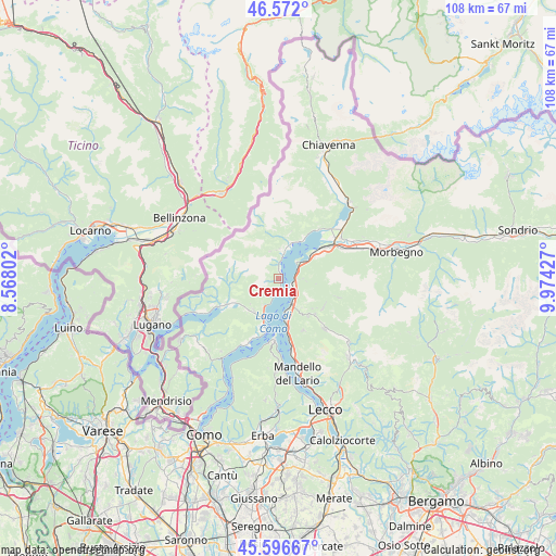
Cremia GPS coordinates[2]
46° 5' 11.364" North, 9° 16' 16.104" East
| Map corner | latitude | longitude |
|---|---|---|
| Upper-left | 46.572°, | 8.56802° |
| Center: | 46.08649°, | 9.27114° |
| Lower-right: | 45.59667°, | 9.97427° |
| Map W x H: | 108.4×108.4 km | = 67.4×67.4mi |
| max Lat: | 47.04031° ⇑6.2% North |
| Cremia: | 46.08649° |
| min Lat: | ⇓93.8% South 35.50142° |
| min Long | Cremia | max Long |
| 6.69888° | 9.27114° | 18.48682° |
| W 23.1%⇐ | ⇒76.9% E |
Elevation
Elevation of Cremia is 345 m = 1132 ft, and this is 38.3 m = 126 ft above average elevation for this country.
| Max E: |
2085 m = 6841 ft | 34.8% |
| Cremia | 345 m 1132 ft | |
| Avg. | 306.7 m = 1006 ft | |
Min E: |
-4 m = -13 ft | 65.2% |
See also: Italy elevation on elevation.city.
Geographical zone
Cremia is located in North temperate zone (between Tropic of Cancer and the Arctic Circle). Distance of this North polar circle is 2276.8 km =1414.7 mi to North.| Distance of | km | miles | from Cremia |
|---|---|---|---|
| North Pole | 4882.7 | 3034 | to North |
| Arctic Circle | 2276.8 | 1414.7 | to North |
| Tropic Cancer | 2518.4 | 1564.9 | to South |
| Equator | 5124.3 | 3184.1 | to South |


Nearby cities:
15 places around Cremia: (largest is in red/bold)
• Bellano
5.5 km =3.4 mi,  149°
149°
• Calozzo
1.6 km =1 mi,  11°
11°
• Dervio
2.9 km =1.8 mi,  111°
111°
• Dongo
4.9 km =3 mi, 9°
• Dorio
4 km =2.5 mi,  67°
67°
• Garzeno
5.5 km =3.4 mi,  342°
342°
• Introzzo
5.4 km =3.4 mi,  96°
96°
• Musso
2.9 km =1.8 mi,  3°
3°
• Pianello del Lario
1.9 km =1.2 mi, 13°
• Plesio
5.4 km =3.4 mi,  216°
216°
• San Siro
2.3 km =1.4 mi,  184°
184°
• Stazzona
5.8 km =3.6 mi, 3°
• Sueglio
4.8 km =3 mi,  90°
90°
• Vestreno
4.2 km =2.6 mi, 94°
• Vignola
0.3 km =0.2 mi,  55°
55°
Sources, notices
• [Note1] Compared only with cities in Italy existing in our database
• [Src1] Map data: © OpenStreetMap contributors (CC-BY-SA)
• [Src2] Other city data from geonames.org with taken over terms of usage.
• [Src3] Geographical zone / Annual Mean Temperature by Robert A. Rohde @ Wikipedia
