Bellano geodata
Bellano (Lombardy) is a seat of a third-order administrative division; located in Italy in Europe/Rome (GMT+2) time zone. With population of 3,050 people, there are 2997 cities with bigger population in this country. Compared to other cities in Italy, 92.9% of cities are located further ↓South; 76.2% of cities are located further →East and 56.4% of cities have lower elevation than Bellano. Note1


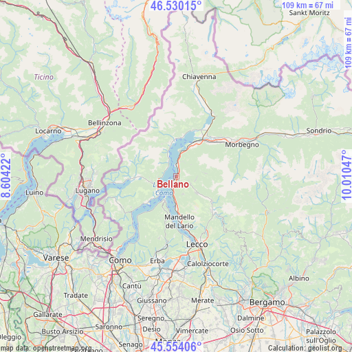
Bellano GPS coordinates[2]
46° 2' 39.336" North, 9° 18' 26.424" East
| Map corner | latitude | longitude |
|---|---|---|
| Upper-left | 46.53015°, | 8.60422° |
| Center: | 46.04426°, | 9.30734° |
| Lower-right: | 45.55406°, | 10.01047° |
| Map W x H: | 108.5×108.5 km | = 67.4×67.4mi |
| max Lat: | 47.04031° ⇑7.1% North |
| Bellano: | 46.04426° |
| min Lat: | ⇓92.9% South 35.50142° |
| min Long | Bellano | max Long |
| 6.69888° | 9.30734° | 18.48682° |
| W 23.8%⇐ | ⇒76.2% E |
Elevation
Elevation of Bellano is 274 m = 899 ft, and this is 32.7 m = 107 ft below average elevation for this country.
| Max E: |
2085 m = 6841 ft | 43.6% |
| Avg. | 306.7 m = 1006 ft | |
| Bellano | 274 m = 899 ft | |
Min E: |
-4 m = -13 ft | 56.4% |
See also: Italy elevation on elevation.city.
Geographical zone
Bellano is located in North temperate zone (between Tropic of Cancer and the Arctic Circle). Distance of this North polar circle is 2281.5 km =1417.7 mi to North.| Distance of | km | miles | from Bellano |
|---|---|---|---|
| North Pole | 4887.4 | 3036.9 | to North |
| Arctic Circle | 2281.5 | 1417.7 | to North |
| Tropic Cancer | 2513.7 | 1561.9 | to South |
| Equator | 5119.6 | 3181.2 | to South |


Nearby cities:
15 places around Bellano: (largest is in red/bold)
• Cremia
5.5 km =3.4 mi,  329°
329°
• Dervio
3.6 km =2.2 mi,  359°
359°
• Esino Lario
5.9 km =3.7 mi,  159°
159°
• Introzzo
4.9 km =3 mi,  32°
32°
• Margno
5.9 km =3.7 mi,  104°
104°
• Parlasco
4.1 km =2.5 mi,  135°
135°
• Perledo
3.3 km =2.1 mi,  195°
195°
• San Siro
3.8 km =2.4 mi,  308°
308°
• Sueglio
5 km =3.1 mi,  23°
23°
• Taceno
5 km =3.1 mi,  118°
118°
• Tremenico
5.7 km =3.5 mi,  52°
52°
• Varenna
4.1 km =2.5 mi,  205°
205°
• Vendrogno
2 km =1.2 mi, 122°
• Vestreno
4.5 km =2.8 mi, 17°
• Vignola
5.5 km =3.4 mi, 332°
Sources, notices
• [Note1] Compared only with cities in Italy existing in our database
• [Src1] Map data: © OpenStreetMap contributors (CC-BY-SA)
• [Src2] Other city data from geonames.org with taken over terms of usage.
• [Src3] Geographical zone / Annual Mean Temperature by Robert A. Rohde @ Wikipedia
