Vestreno geodata
Vestreno (Lombardy) is a seat of a third-order administrative division; located in Italy in Europe/Rome (GMT+2) time zone. With population of 228 people, there are 10990 cities with bigger population in this country. Compared to other cities in Italy, 93.8% of cities are located further ↓South; 75.9% of cities are located further →East and 82.2% of cities have lower elevation than Vestreno. Note1


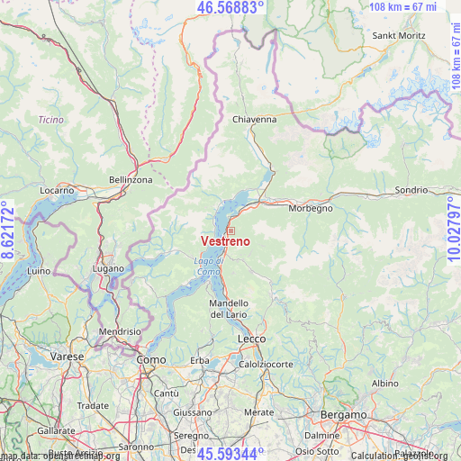
Vestreno GPS coordinates[2]
46° 4' 59.844" North, 9° 19' 29.424" East
| Map corner | latitude | longitude |
|---|---|---|
| Upper-left | 46.56883°, | 8.62172° |
| Center: | 46.08329°, | 9.32484° |
| Lower-right: | 45.59344°, | 10.02797° |
| Map W x H: | 108.5×108.5 km | = 67.4×67.4mi |
| max Lat: | 47.04031° ⇑6.2% North |
| Vestreno: | 46.08329° |
| min Lat: | ⇓93.8% South 35.50142° |
| min Long | Vestreno | max Long |
| 6.69888° | 9.32484° | 18.48682° |
| W 24.1%⇐ | ⇒75.9% E |
Elevation
Elevation of Vestreno is 558 m = 1831 ft, and this is 251.3 m = 824 ft above average elevation for this country.
| Max E: |
2085 m = 6841 ft | 17.8% |
| Vestreno | 558 m 1831 ft | |
| Avg. | 306.7 m = 1006 ft | |
Min E: |
-4 m = -13 ft | 82.2% |
See also: Italy elevation on elevation.city.
Geographical zone
Vestreno is located in North temperate zone (between Tropic of Cancer and the Arctic Circle). Distance of this North polar circle is 2277.2 km =1415 mi to North.| Distance of | km | miles | from Vestreno |
|---|---|---|---|
| North Pole | 4883.1 | 3034.2 | to North |
| Arctic Circle | 2277.2 | 1415 | to North |
| Tropic Cancer | 2518.1 | 1564.7 | to South |
| Equator | 5124 | 3183.9 | to South |


Nearby cities:
15 places around Vestreno: (largest is in red/bold)
• Bellano
4.5 km =2.8 mi,  197°
197°
• Calozzo
4.3 km =2.7 mi,  296°
296°
• Cremia
4.2 km =2.6 mi,  274°
274°
• Dervio
1.6 km =1 mi,  243°
243°
• Dongo
6.2 km =3.9 mi,  327°
327°
• Dorio
1.9 km =1.2 mi,  346°
346°
• Introzzo
1.3 km =0.8 mi,  100°
100°
• Musso
5.1 km =3.2 mi,  309°
309°
• Pagnona
6.6 km =4.1 mi,  113°
113°
• Pianello del Lario
4.3 km =2.7 mi, 300°
• San Siro
4.7 km =2.9 mi,  245°
245°
• Sueglio
0.7 km =0.4 mi,  67°
67°
• Tremenico
3.3 km =2.1 mi, 104°
• Vendrogno
5.4 km =3.4 mi,  176°
176°
• Vignola
3.9 km =2.4 mi,  277°
277°
Sources, notices
• [Note1] Compared only with cities in Italy existing in our database
• [Src1] Map data: © OpenStreetMap contributors (CC-BY-SA)
• [Src2] Other city data from geonames.org with taken over terms of usage.
• [Src3] Geographical zone / Annual Mean Temperature by Robert A. Rohde @ Wikipedia
