Calozzo geodata
Calozzo (Lombardy) is a seat of a third-order administrative division; located in Italy in Europe/Rome (GMT+2) time zone. With population of 1,028 people, there are 6547 cities with bigger population in this country. Compared to other cities in Italy, 94.1% of cities are located further ↓South; 76.8% of cities are located further →East and 51.1% of cities have higher elevation than Calozzo. Note1
Administrative division(s):
- Level 1: Lombardy
- Level 2: Provincia di Como
- Level 3: Pianello del Lario


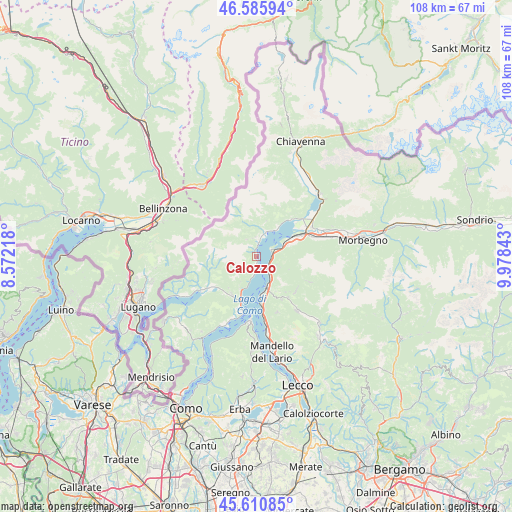
Calozzo GPS coordinates[2]
46° 6' 1.98" North, 9° 16' 31.116" East
| Map corner | latitude | longitude |
|---|---|---|
| Upper-left | 46.58594°, | 8.57218° |
| Center: | 46.10055°, | 9.27531° |
| Lower-right: | 45.61085°, | 9.97843° |
| Map W x H: | 108.4×108.4 km | = 67.4×67.4mi |
| max Lat: | 47.04031° ⇑5.9% North |
| Calozzo: | 46.10055° |
| min Lat: | ⇓94.1% South 35.50142° |
| min Long | Calozzo | max Long |
| 6.69888° | 9.27531° | 18.48682° |
| W 23.2%⇐ | ⇒76.8% E |
Elevation
Elevation of Calozzo is 227 m = 745 ft, and this is 79.7 m = 261 ft below average elevation for this country.
| Max E: |
2085 m = 6841 ft | 51.1% |
| Avg. | 306.7 m = 1006 ft | |
| Calozzo | 227 m = 745 ft | |
Min E: |
-4 m = -13 ft | 48.9% |
See also: Italy elevation on elevation.city.
Geographical zone
Calozzo is located in North temperate zone (between Tropic of Cancer and the Arctic Circle). Distance of this North polar circle is 2275.3 km =1413.8 mi to North.| Distance of | km | miles | from Calozzo |
|---|---|---|---|
| North Pole | 4881.2 | 3033 | to North |
| Arctic Circle | 2275.3 | 1413.8 | to North |
| Tropic Cancer | 2520 | 1565.9 | to South |
| Equator | 5125.9 | 3185.1 | to South |


Nearby cities:
15 places around Calozzo: (largest is in red/bold)
• Consiglio di Rumo
4.9 km =3 mi,  16°
16°
• Cremia
1.6 km =1 mi,  191°
191°
• Dervio
3.6 km =2.2 mi,  137°
137°
• Dongo
3.3 km =2.1 mi,  8°
8°
• Dorio
3.4 km =2.1 mi,  90°
90°
• Garzeno
4.2 km =2.6 mi,  332°
332°
• Gravedona-San Gregorio
5.5 km =3.4 mi, 21°
• Introzzo
5.5 km =3.4 mi,  113°
113°
• Musso
1.4 km =0.9 mi,  355°
355°
• Pianello del Lario
0.3 km =0.2 mi,  26°
26°
• San Siro
3.9 km =2.4 mi, 187°
• Stazzona
4.3 km =2.7 mi, 359°
• Sueglio
4.8 km =3 mi, 110°
• Vestreno
4.3 km =2.7 mi,  116°
116°
• Vignola
1.4 km =0.9 mi,  182°
182°
Sources, notices
• [Note1] Compared only with cities in Italy existing in our database
• [Src1] Map data: © OpenStreetMap contributors (CC-BY-SA)
• [Src2] Other city data from geonames.org with taken over terms of usage.
• [Src3] Geographical zone / Annual Mean Temperature by Robert A. Rohde @ Wikipedia
