Bedulita geodata
Bedulita (Lombardy) is a seat of a third-order administrative division; located in Italy in Europe/Rome (GMT+2) time zone. With population of 710 people, there are 8228 cities with bigger population in this country. Compared to other cities in Italy, 85.4% of cities are located further ↓South; 72.6% of cities are located further →East and 84.2% of cities have lower elevation than Bedulita. Note1


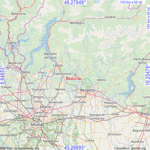
Bedulita GPS coordinates[2]
45° 47' 28.968" North, 9° 33' 5.94" East
| Map corner | latitude | longitude |
|---|---|---|
| Upper-left | 46.27949°, | 8.84853° |
| Center: | 45.79138°, | 9.55165° |
| Lower-right: | 45.29895°, | 10.25478° |
| Map W x H: | 109×109 km | = 67.7×67.7mi |
| max Lat: | 47.04031° ⇑14.6% North |
| Bedulita: | 45.79138° |
| min Lat: | ⇓85.4% South 35.50142° |
| min Long | Bedulita | max Long |
| 6.69888° | 9.55165° | 18.48682° |
| W 27.4%⇐ | ⇒72.6% E |
Elevation
Elevation of Bedulita is 596 m = 1955 ft, and this is 289.3 m = 949 ft above average elevation for this country.
| Max E: |
2085 m = 6841 ft | 15.8% |
| Bedulita | 596 m 1955 ft | |
| Avg. | 306.7 m = 1006 ft | |
Min E: |
-4 m = -13 ft | 84.2% |
See also: Italy elevation on elevation.city.
Geographical zone
Bedulita is located in North temperate zone (between Tropic of Cancer and the Arctic Circle). Distance of this North polar circle is 2309.6 km =1435.1 mi to North.| Distance of | km | miles | from Bedulita |
|---|---|---|---|
| North Pole | 4915.5 | 3054.3 | to North |
| Arctic Circle | 2309.6 | 1435.1 | to North |
| Tropic Cancer | 2485.6 | 1544.5 | to South |
| Equator | 5091.5 | 3163.7 | to South |


Nearby cities:
15 places around Bedulita: (largest is in red/bold)
• Berbenno
3 km =1.9 mi,  30°
30°
• Botta
4.8 km =3 mi,  341°
341°
• Brembilla
4.8 km =3 mi,  46°
46°
• Camoneone
1.5 km =0.9 mi,  115°
115°
• Corna Imagna
4.4 km =2.7 mi,  353°
353°
• Costa Valle Imagna
3.9 km =2.4 mi,  289°
289°
• Laxolo
4.2 km =2.6 mi,  62°
62°
• Locatello
5.1 km =3.2 mi, 344°
• Palazzago
4.5 km =2.8 mi,  198°
198°
• Roncola
2.6 km =1.6 mi,  164°
164°
• Sant'Omobono Terme
2.2 km =1.4 mi,  327°
327°
• Selino Basso
2.5 km =1.6 mi, 328°
• Strozza
2.9 km =1.8 mi,  134°
134°
• Ubiale
5.1 km =3.2 mi,  99°
99°
• Ubiale Clanezzo
5.3 km =3.3 mi, 99°
Sources, notices
• [Note1] Compared only with cities in Italy existing in our database
• [Src1] Map data: © OpenStreetMap contributors (CC-BY-SA)
• [Src2] Other city data from geonames.org with taken over terms of usage.
• [Src3] Geographical zone / Annual Mean Temperature by Robert A. Rohde @ Wikipedia
