Corna Imagna geodata
Corna Imagna (Lombardy) is a seat of a third-order administrative division; located in Italy in Europe/Rome (GMT+2) time zone. With population of 337 people, there are 10523 cities with bigger population in this country. Compared to other cities in Italy, 87.1% of cities are located further ↓South; 72.7% of cities are located further →East and 90.1% of cities have lower elevation than Corna Imagna. Note1


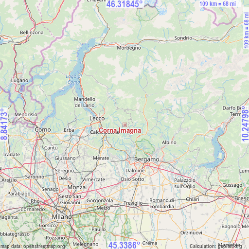
Corna Imagna GPS coordinates[2]
45° 49' 50.448" North, 9° 32' 41.46" East
| Map corner | latitude | longitude |
|---|---|---|
| Upper-left | 46.31845°, | 8.84173° |
| Center: | 45.83068°, | 9.54485° |
| Lower-right: | 45.3386°, | 10.24798° |
| Map W x H: | 108.9×108.9 km | = 67.7×67.7mi |
| max Lat: | 47.04031° ⇑12.9% North |
| Corna Imagna: | 45.83068° |
| min Lat: | ⇓87.1% South 35.50142° |
| min Long | Corna Imagna | max Long |
| 6.69888° | 9.54485° | 18.48682° |
| W 27.3%⇐ | ⇒72.7% E |
Elevation
Elevation of Corna Imagna is 723 m = 2372 ft, and this is 416.3 m = 1366 ft above average elevation for this country.
| Max E: |
2085 m = 6841 ft | 9.9% |
| Corna Imagna | 723 m 2372 ft | |
| Avg. | 306.7 m = 1006 ft | |
Min E: |
-4 m = -13 ft | 90.1% |
See also: Italy elevation on elevation.city.
Geographical zone
Corna Imagna is located in North temperate zone (between Tropic of Cancer and the Arctic Circle). Distance of this North polar circle is 2305.3 km =1432.4 mi to North.| Distance of | km | miles | from Corna Imagna |
|---|---|---|---|
| North Pole | 4911.2 | 3051.7 | to North |
| Arctic Circle | 2305.3 | 1432.4 | to North |
| Tropic Cancer | 2490 | 1547.2 | to South |
| Equator | 5095.9 | 3166.4 | to South |


Nearby cities:
15 places around Corna Imagna: (largest is in red/bold)
• Bedulita
4.4 km =2.7 mi,  173°
173°
• Berbenno
2.7 km =1.7 mi,  131°
131°
• Blello
2.2 km =1.4 mi,  68°
68°
• Botta
1 km =0.6 mi,  280°
280°
• Brembilla
4.2 km =2.6 mi,  104°
104°
• Brumano
4.3 km =2.7 mi,  307°
307°
• Calchera-Frontale
2.6 km =1.6 mi, 278°
• Costa Valle Imagna
4.4 km =2.7 mi,  225°
225°
• Fuipiano Valle Imagna
2.9 km =1.8 mi,  334°
334°
• Gerosa
3 km =1.9 mi,  44°
44°
• Laxolo
4.9 km =3 mi,  119°
119°
• Locatello
1 km =0.6 mi,  300°
300°
• Rota d'Imagna
2.5 km =1.6 mi,  270°
270°
• Sant'Omobono Terme
2.6 km =1.6 mi,  195°
195°
• Selino Basso
2.4 km =1.5 mi, 198°
Sources, notices
• [Note1] Compared only with cities in Italy existing in our database
• [Src1] Map data: © OpenStreetMap contributors (CC-BY-SA)
• [Src2] Other city data from geonames.org with taken over terms of usage.
• [Src3] Geographical zone / Annual Mean Temperature by Robert A. Rohde @ Wikipedia
