Laxolo geodata
Laxolo (Lombardy) is a populated place; located in Italy in Europe/Rome (GMT+2) time zone. With population of 1,032 people, there are 6537 cities with bigger population in this country. Compared to other cities in Italy, 86.1% of cities are located further ↓South; 72% of cities are located further →East and 80.1% of cities have lower elevation than Laxolo. Note1


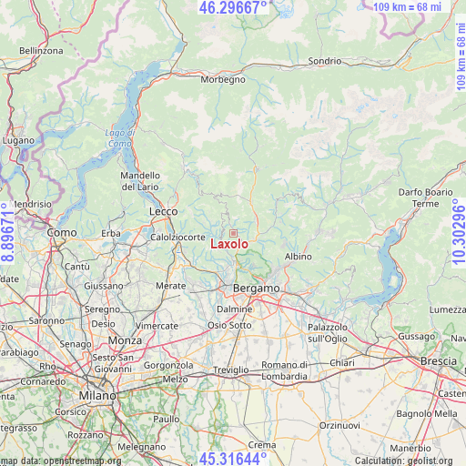
Laxolo GPS coordinates[2]
45° 48' 31.356" North, 9° 35' 59.388" East
| Map corner | latitude | longitude |
|---|---|---|
| Upper-left | 46.29667°, | 8.89671° |
| Center: | 45.80871°, | 9.59983° |
| Lower-right: | 45.31644°, | 10.30296° |
| Map W x H: | 109×109 km | = 67.7×67.7mi |
| max Lat: | 47.04031° ⇑13.9% North |
| Laxolo: | 45.80871° |
| min Lat: | ⇓86.1% South 35.50142° |
| min Long | Laxolo | max Long |
| 6.69888° | 9.59983° | 18.48682° |
| W 28%⇐ | ⇒72% E |
Elevation
Elevation of Laxolo is 527 m = 1729 ft, and this is 220.3 m = 723 ft above average elevation for this country.
| Max E: |
2085 m = 6841 ft | 19.9% |
| Laxolo | 527 m 1729 ft | |
| Avg. | 306.7 m = 1006 ft | |
Min E: |
-4 m = -13 ft | 80.1% |
See also: Italy elevation on elevation.city.
Geographical zone
Laxolo is located in North temperate zone (between Tropic of Cancer and the Arctic Circle). Distance of this North polar circle is 2307.7 km =1433.9 mi to North.| Distance of | km | miles | from Laxolo |
|---|---|---|---|
| North Pole | 4913.6 | 3053.2 | to North |
| Arctic Circle | 2307.7 | 1433.9 | to North |
| Tropic Cancer | 2487.5 | 1545.7 | to South |
| Equator | 5093.5 | 3165 | to South |


Nearby cities:
15 places around Laxolo: (largest is in red/bold)
• Bedulita
4.2 km =2.6 mi,  242°
242°
• Berbenno
2.3 km =1.4 mi,  286°
286°
• Blello
3.9 km =2.4 mi,  325°
325°
• Botta
4.7 km =2.9 mi,  166°
166°
• Brembilla
1.4 km =0.9 mi,  350°
350°
• Camoneone
3.5 km =2.2 mi,  222°
222°
• Corna Imagna
4.9 km =3 mi,  299°
299°
• Gerosa
5.1 km =3.2 mi, 334°
• Sant'Omobono Terme
4.9 km =3 mi,  269°
269°
• Sedrina
3.6 km =2.2 mi,  149°
149°
• Selino Basso
5 km =3.1 mi, 272°
• Strozza
4.3 km =2.7 mi,  202°
202°
• Ubiale
3.1 km =1.9 mi,  155°
155°
• Ubiale Clanezzo
3.2 km =2 mi, 151°
• Zogno
4.9 km =3 mi,  109°
109°
Sources, notices
• [Note1] Compared only with cities in Italy existing in our database
• [Src1] Map data: © OpenStreetMap contributors (CC-BY-SA)
• [Src2] Other city data from geonames.org with taken over terms of usage.
• [Src3] Geographical zone / Annual Mean Temperature by Robert A. Rohde @ Wikipedia
