Montemignaio geodata
Montemignaio (Tuscany) is a seat of a third-order administrative division; located in Italy in Europe/Rome (GMT+2) time zone. With population of 589 people, there are 9105 cities with bigger population in this country. Compared to other cities in Italy, 57.6% of cities are located further ↑North; 50.8% of cities are located further ←West and 91.6% of cities have lower elevation than Montemignaio. Note1


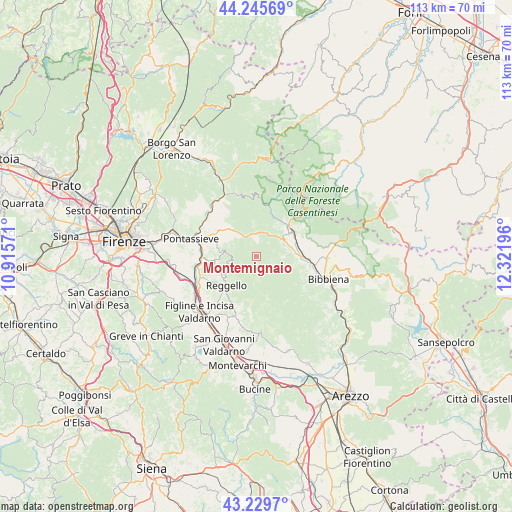
Montemignaio GPS coordinates[2]
43° 44' 23.46" North, 11° 37' 7.788" East
| Map corner | latitude | longitude |
|---|---|---|
| Upper-left | 44.24569°, | 10.91571° |
| Center: | 43.73985°, | 11.61883° |
| Lower-right: | 43.2297°, | 12.32196° |
| Map W x H: | 113×113 km | = 70.2×70.2mi |
| max Lat: | 47.04031° ⇑57.6% North |
| Montemignaio: | 43.73985° |
| min Lat: | ⇓42.4% South 35.50142° |
| min Long | Montemignaio | max Long |
| 6.69888° | 11.61883° | 18.48682° |
| W 50.8%⇐ | ⇒49.2% E |
Elevation
Elevation of Montemignaio is 758 m = 2487 ft, and this is 451.3 m = 1481 ft above average elevation for this country.
| Max E: |
2085 m = 6841 ft | 8.4% |
| Montemignaio | 758 m 2487 ft | |
| Avg. | 306.7 m = 1006 ft | |
Min E: |
-4 m = -13 ft | 91.6% |
See also: Italy elevation on elevation.city.
Geographical zone
Montemignaio is located in North temperate zone (between Tropic of Cancer and the Arctic Circle). Distance of this Northern Tropic circle is 2257.5 km =1402.7 mi to South.| Distance of | km | miles | from Montemignaio |
|---|---|---|---|
| North Pole | 5143.6 | 3196.1 | to North |
| Arctic Circle | 2537.8 | 1576.9 | to North |
| Tropic Cancer | 2257.5 | 1402.7 | to South |
| Equator | 4863.4 | 3022 | to South |


Nearby cities:
15 places around Montemignaio: (largest is in red/bold)
• Cancelli
10.4 km =6.5 mi,  236°
236°
• Castel San Niccolò
7.3 km =4.5 mi,  85°
85°
• Diacceto
10.5 km =6.5 mi,  297°
297°
• Donnini
9.5 km =5.9 mi,  265°
265°
• La Pieve-Molino
0.3 km =0.2 mi,  157°
157°
• Ortignano Raggiolo
12.4 km =7.7 mi,  122°
122°
• Pelago
10.1 km =6.3 mi,  291°
291°
• Pietrapiana
8.6 km =5.3 mi, 235°
• Ponte a Poppi
11.9 km =7.4 mi, 94°
• Poppi
12 km =7.5 mi,  99°
99°
• Pratovecchio
9.9 km =6.2 mi,  58°
58°
• Reggello
9.8 km =6.1 mi,  226°
226°
• Stia
9.8 km =6.1 mi,  47°
47°
• Strada
7.3 km =4.5 mi, 85°
• Tosi
7 km =4.3 mi,  278°
278°
Sources, notices
• [Note1] Compared only with cities in Italy existing in our database
• [Src1] Map data: © OpenStreetMap contributors (CC-BY-SA)
• [Src2] Other city data from geonames.org with taken over terms of usage.
• [Src3] Geographical zone / Annual Mean Temperature by Robert A. Rohde @ Wikipedia
