Stia geodata
Stia (Tuscany) is a seat of a third-order administrative division; located in Italy in Europe/Rome (GMT+2) time zone. With population of 2,359 people, there are 3684 cities with bigger population in this country. Compared to other cities in Italy, 57% of cities are located further ↑North; 51.9% of cities are located further ←West and 75% of cities have lower elevation than Stia. Note1


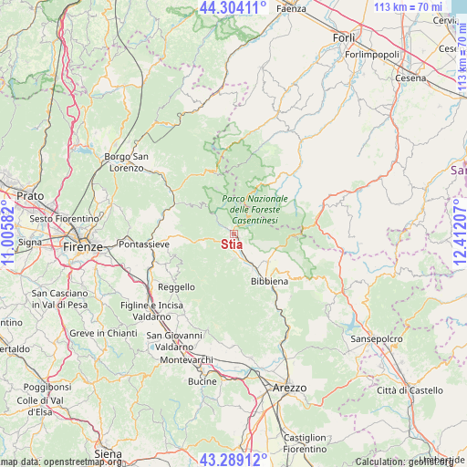
Stia GPS coordinates[2]
43° 47' 55.572" North, 11° 42' 32.184" East
| Map corner | latitude | longitude |
|---|---|---|
| Upper-left | 44.30411°, | 11.00582° |
| Center: | 43.79877°, | 11.70894° |
| Lower-right: | 43.28912°, | 12.41207° |
| Map W x H: | 112.9×112.9 km | = 70.2×70.2mi |
| max Lat: | 47.04031° ⇑57% North |
| Stia: | 43.79877° |
| min Lat: | ⇓43% South 35.50142° |
| min Long | Stia | max Long |
| 6.69888° | 11.70894° | 18.48682° |
| W 51.9%⇐ | ⇒48.1% E |
Elevation
Elevation of Stia is 452 m = 1483 ft, and this is 145.3 m = 477 ft above average elevation for this country.
| Max E: |
2085 m = 6841 ft | 25% |
| Stia | 452 m 1483 ft | |
| Avg. | 306.7 m = 1006 ft | |
Min E: |
-4 m = -13 ft | 75% |
See also: Italy elevation on elevation.city.
Geographical zone
Stia is located in North temperate zone (between Tropic of Cancer and the Arctic Circle). Distance of this Northern Tropic circle is 2264 km =1406.8 mi to South.| Distance of | km | miles | from Stia |
|---|---|---|---|
| North Pole | 5137.1 | 3192 | to North |
| Arctic Circle | 2531.2 | 1572.8 | to North |
| Tropic Cancer | 2264 | 1406.8 | to South |
| Equator | 4870 | 3026.1 | to South |


Nearby cities:
15 places around Stia: (largest is in red/bold)
• Badia Prataglia
13.6 km =8.5 mi,  92°
92°
• Bibbiena
14 km =8.7 mi,  142°
142°
• Castel San Niccolò
6 km =3.7 mi,  179°
179°
• I filipponi
14.1 km =8.8 mi,  301°
301°
• La Pieve-Molino
9.9 km =6.2 mi,  226°
226°
• Londa
13.7 km =8.5 mi, 301°
• Montemignaio
9.8 km =6.1 mi, 227°
• Ortignano Raggiolo
13.6 km =8.5 mi,  166°
166°
• Partina
10.6 km =6.6 mi,  121°
121°
• Ponte a Poppi
8.8 km =5.5 mi,  148°
148°
• Poppi
9.8 km =6.1 mi, 151°
• Pratovecchio
1.8 km =1.1 mi, 138°
• Soci
11.3 km =7 mi,  133°
133°
• Strada
6 km =3.7 mi, 179°
• Tosi
15.2 km =9.4 mi,  248°
248°
Sources, notices
• [Note1] Compared only with cities in Italy existing in our database
• [Src1] Map data: © OpenStreetMap contributors (CC-BY-SA)
• [Src2] Other city data from geonames.org with taken over terms of usage.
• [Src3] Geographical zone / Annual Mean Temperature by Robert A. Rohde @ Wikipedia
