Senale geodata
Senale (Trentino-Alto Adige) is a seat of a third-order administrative division; located in Italy in Europe/Rome (GMT+2) time zone. With population of 68 people, there are 11544 cities with bigger population in this country. Compared to other cities in Italy, 98.4% of cities are located further ↓South; 55.8% of cities are located further →East and 99.3% of cities have lower elevation than Senale. Note1
Administrative division(s):
- Level 1: Trentino-Alto Adige
- Level 2: Bolzano
- Level 3: Senale-San Felice


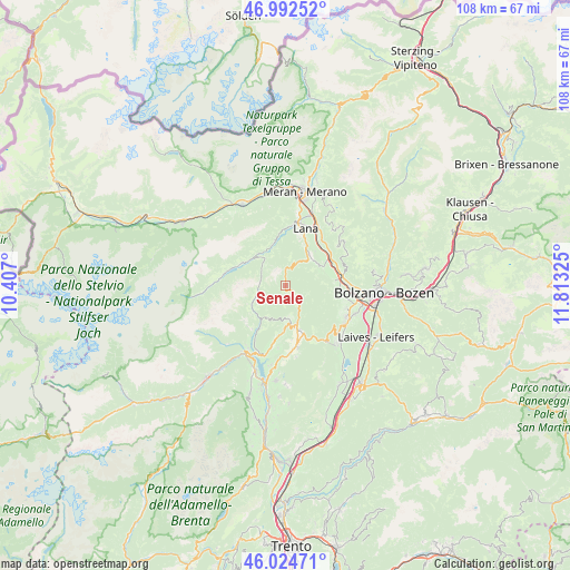
Senale GPS coordinates[2]
46° 30' 38.772" North, 11° 6' 36.432" East
| Map corner | latitude | longitude |
|---|---|---|
| Upper-left | 46.99252°, | 10.407° |
| Center: | 46.51077°, | 11.11012° |
| Lower-right: | 46.02471°, | 11.81325° |
| Map W x H: | 107.6×107.6 km | = 66.9×66.9mi |
| max Lat: | 47.04031° ⇑1.6% North |
| Senale: | 46.51077° |
| min Lat: | ⇓98.4% South 35.50142° |
| min Long | Senale | max Long |
| 6.69888° | 11.11012° | 18.48682° |
| W 44.2%⇐ | ⇒55.8% E |
Elevation
Elevation of Senale is 1354 m = 4442 ft, and this is 1047.3 m = 3436 ft above average elevation for this country.
| Max E: |
2085 m = 6841 ft | 0.7% |
| Senale | 1354 m 4442 ft | |
| Avg. | 306.7 m = 1006 ft | |
Min E: |
-4 m = -13 ft | 99.3% |
See also: Italy elevation on elevation.city.
Geographical zone
Senale is located in North temperate zone (between Tropic of Cancer and the Arctic Circle). Distance of this North polar circle is 2229.7 km =1385.5 mi to North.| Distance of | km | miles | from Senale |
|---|---|---|---|
| North Pole | 4835.5 | 3004.6 | to North |
| Arctic Circle | 2229.7 | 1385.5 | to North |
| Tropic Cancer | 2565.6 | 1594.2 | to South |
| Equator | 5171.5 | 3213.4 | to South |


Nearby cities:
15 places around Senale: (largest is in red/bold)
• Andriano
9.3 km =5.8 mi,  85°
85°
• Brez
8.7 km =5.4 mi,  182°
182°
• Castelfondo
6.1 km =3.8 mi,  174°
174°
• Foiana
9.5 km =5.9 mi,  17°
17°
• Fondo
8.3 km =5.2 mi, 165°
• Lauregno
7.3 km =4.5 mi,  210°
210°
• Malosco
8.8 km =5.5 mi,  161°
161°
• Nalles
8.2 km =5.1 mi,  63°
63°
• Proves - Proveis
7.7 km =4.8 mi,  240°
240°
• Ronzone
10.1 km =6.3 mi, 161°
• San Felice
2.4 km =1.5 mi,  139°
139°
• San Pancrazio
8.6 km =5.3 mi,  347°
347°
• Santa Valburga
9.5 km =5.9 mi,  297°
297°
• Tesimo
7.6 km =4.7 mi,  36°
36°
• Ultimo - Ulten
9.1 km =5.7 mi, 297°
Sources, notices
• [Note1] Compared only with cities in Italy existing in our database
• [Src1] Map data: © OpenStreetMap contributors (CC-BY-SA)
• [Src2] Other city data from geonames.org with taken over terms of usage.
• [Src3] Geographical zone / Annual Mean Temperature by Robert A. Rohde @ Wikipedia
