Tirolo geodata
Tirolo (Trentino-Alto Adige) is a seat of a third-order administrative division; located in Italy in Europe/Rome (GMT+2) time zone. With population of 1,149 people, there are 6115 cities with bigger population in this country. Compared to other cities in Italy, 99.3% of cities are located further ↓South; 55.1% of cities are located further →East and 84.5% of cities have lower elevation than Tirolo. Note1


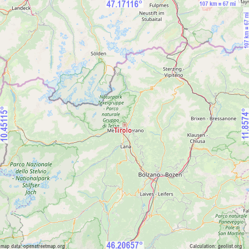
Tirolo GPS coordinates[2]
46° 41' 27.672" North, 11° 9' 15.372" East
| Map corner | latitude | longitude |
|---|---|---|
| Upper-left | 47.17116°, | 10.45115° |
| Center: | 46.69102°, | 11.15427° |
| Lower-right: | 46.20657°, | 11.8574° |
| Map W x H: | 107.3×107.3 km | = 66.7×66.7mi |
| max Lat: | 47.04031° ⇑0.7% North |
| Tirolo: | 46.69102° |
| min Lat: | ⇓99.3% South 35.50142° |
| min Long | Tirolo | max Long |
| 6.69888° | 11.15427° | 18.48682° |
| W 44.9%⇐ | ⇒55.1% E |
Elevation
Elevation of Tirolo is 600 m = 1969 ft, and this is 293.3 m = 962 ft above average elevation for this country.
| Max E: |
2085 m = 6841 ft | 15.5% |
| Tirolo | 600 m 1969 ft | |
| Avg. | 306.7 m = 1006 ft | |
Min E: |
-4 m = -13 ft | 84.5% |
See also: Italy elevation on elevation.city.
Geographical zone
Tirolo is located in North temperate zone (between Tropic of Cancer and the Arctic Circle). Distance of this North polar circle is 2209.6 km =1373 mi to North.| Distance of | km | miles | from Tirolo |
|---|---|---|---|
| North Pole | 4815.5 | 2992.2 | to North |
| Arctic Circle | 2209.6 | 1373 | to North |
| Tropic Cancer | 2585.6 | 1606.6 | to South |
| Equator | 5191.6 | 3225.9 | to South |


Nearby cities:
15 places around Tirolo: (largest is in red/bold)
• Avelengo
7.3 km =4.5 mi,  133°
133°
• Caines
1.5 km =0.9 mi,  59°
59°
• Caines - Kuens
1.6 km =1 mi,  49°
49°
• Cermes
6.5 km =4 mi,  184°
184°
• Lagundo
2.4 km =1.5 mi,  243°
243°
• Lana
8.8 km =5.5 mi, 178°
• Marlengo
4.3 km =2.7 mi,  188°
188°
• Merano
2.6 km =1.6 mi,  171°
171°
• Parcines
6.2 km =3.9 mi,  263°
263°
• Rablà
7.2 km =4.5 mi,  251°
251°
• Rifiano
2.4 km =1.5 mi, 56°
• Scena
2.6 km =1.6 mi,  96°
96°
• Scena - Schenna
2.4 km =1.5 mi,  92°
92°
• Sinigo
6.5 km =4 mi,  163°
163°
• Zona Laurin
1.6 km =1 mi,  207°
207°
Sources, notices
• [Note1] Compared only with cities in Italy existing in our database
• [Src1] Map data: © OpenStreetMap contributors (CC-BY-SA)
• [Src2] Other city data from geonames.org with taken over terms of usage.
• [Src3] Geographical zone / Annual Mean Temperature by Robert A. Rohde @ Wikipedia
