Pocapaglia geodata
Pocapaglia (Piedmont) is a seat of a third-order administrative division; located in Italy in Europe/Rome (GMT+2) time zone. With population of 699 people, there are 8309 cities with bigger population in this country. Compared to other cities in Italy, 54.5% of cities are located further ↓South; 94.8% of cities are located further →East and 57.1% of cities have lower elevation than Pocapaglia. Note1


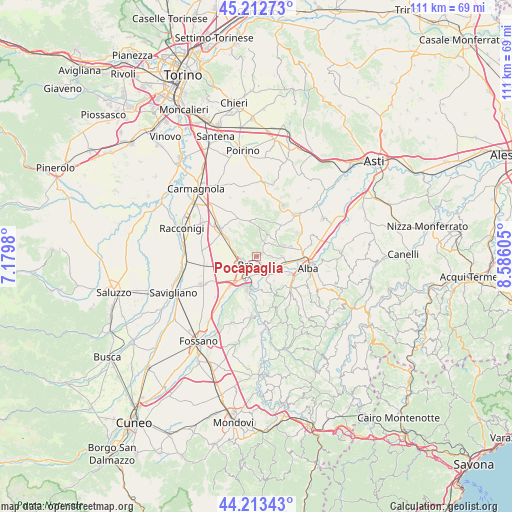
Pocapaglia GPS coordinates[2]
44° 42' 54.864" North, 7° 52' 58.548" East
| Map corner | latitude | longitude |
|---|---|---|
| Upper-left | 45.21273°, | 7.1798° |
| Center: | 44.71524°, | 7.88293° |
| Lower-right: | 44.21343°, | 8.58605° |
| Map W x H: | 111.1×111.1 km | = 69×69mi |
| max Lat: | 47.04031° ⇑45.5% North |
| Pocapaglia: | 44.71524° |
| min Lat: | ⇓54.5% South 35.50142° |
| min Long | Pocapaglia | max Long |
| 6.69888° | 7.88293° | 18.48682° |
| W 5.2%⇐ | ⇒94.8% E |
Elevation
Elevation of Pocapaglia is 279 m = 915 ft, and this is 27.7 m = 91 ft below average elevation for this country.
| Max E: |
2085 m = 6841 ft | 42.9% |
| Avg. | 306.7 m = 1006 ft | |
| Pocapaglia | 279 m = 915 ft | |
Min E: |
-4 m = -13 ft | 57.1% |
See also: Italy elevation on elevation.city.
Geographical zone
Pocapaglia is located in North temperate zone (between Tropic of Cancer and the Arctic Circle). Distance of this Northern Tropic circle is 2365.9 km =1470.1 mi to South.| Distance of | km | miles | from Pocapaglia |
|---|---|---|---|
| North Pole | 5035.2 | 3128.7 | to North |
| Arctic Circle | 2429.3 | 1509.5 | to North |
| Tropic Cancer | 2365.9 | 1470.1 | to South |
| Equator | 4971.9 | 3089.4 | to South |


Nearby cities:
15 places around Pocapaglia: (largest is in red/bold)
• Baldissero d'Alba
5.6 km =3.5 mi,  21°
21°
• Bandito
4.7 km =2.9 mi,  280°
280°
• Borgo
6.3 km =3.9 mi,  96°
96°
• Borgo San Martino
1.7 km =1.1 mi,  167°
167°
• Bra
3.2 km =2 mi,  232°
232°
• Cinzano
3.9 km =2.4 mi,  129°
129°
• Corneliano d'Alba
6.3 km =3.9 mi,  68°
68°
• Monticello d'Alba
4.7 km =2.9 mi,  85°
85°
• Pollenzo
3.3 km =2.1 mi,  163°
163°
• Roreto
6.4 km =4 mi,  217°
217°
• Santa Vittoria d'Alba
4.7 km =2.9 mi,  113°
113°
• Sommariva Perno
3.7 km =2.3 mi, 22°
• Villa
3.7 km =2.3 mi, 22°
• Villa
4.6 km =2.9 mi,  84°
84°
• Villa-Borgo
4.5 km =2.8 mi, 114°
Sources, notices
• [Note1] Compared only with cities in Italy existing in our database
• [Src1] Map data: © OpenStreetMap contributors (CC-BY-SA)
• [Src2] Other city data from geonames.org with taken over terms of usage.
• [Src3] Geographical zone / Annual Mean Temperature by Robert A. Rohde @ Wikipedia
