Duno geodata
Duno (Lombardy) is a seat of a third-order administrative division; located in Italy in Europe/Rome (GMT+2) time zone. With population of 147 people, there are 11292 cities with bigger population in this country. Compared to other cities in Italy, 89.6% of cities are located further ↓South; 85% of cities are located further →East and 81.6% of cities have lower elevation than Duno. Note1


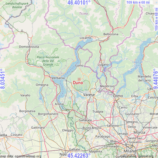
Duno GPS coordinates[2]
45° 54' 50.328" North, 8° 44' 15.468" East
| Map corner | latitude | longitude |
|---|---|---|
| Upper-left | 46.40101°, | 8.03451° |
| Center: | 45.91398°, | 8.73763° |
| Lower-right: | 45.42263°, | 9.44076° |
| Map W x H: | 108.8×108.8 km | = 67.6×67.6mi |
| max Lat: | 47.04031° ⇑10.4% North |
| Duno: | 45.91398° |
| min Lat: | ⇓89.6% South 35.50142° |
| min Long | Duno | max Long |
| 6.69888° | 8.73763° | 18.48682° |
| W 15%⇐ | ⇒85% E |
Elevation
Elevation of Duno is 547 m = 1795 ft, and this is 240.3 m = 788 ft above average elevation for this country.
| Max E: |
2085 m = 6841 ft | 18.4% |
| Duno | 547 m 1795 ft | |
| Avg. | 306.7 m = 1006 ft | |
Min E: |
-4 m = -13 ft | 81.6% |
See also: Italy elevation on elevation.city.
Geographical zone
Duno is located in North temperate zone (between Tropic of Cancer and the Arctic Circle). Distance of this North polar circle is 2296 km =1426.7 mi to North.| Distance of | km | miles | from Duno |
|---|---|---|---|
| North Pole | 4901.9 | 3045.9 | to North |
| Arctic Circle | 2296 | 1426.7 | to North |
| Tropic Cancer | 2499.2 | 1552.9 | to South |
| Equator | 5105.2 | 3172.2 | to South |


Nearby cities:
15 places around Duno: (largest is in red/bold)
• Azzio
4 km =2.5 mi,  214°
214°
• Bedero Valcuvia
4.5 km =2.8 mi,  94°
94°
• Brenta
4.7 km =2.9 mi,  242°
242°
• Brinzio
4.7 km =2.9 mi,  125°
125°
• Brissago-Valtravaglia
4 km =2.5 mi,  9°
9°
• Casalzuigno
2.4 km =1.5 mi,  246°
246°
• Cassano Valcuvia
3.1 km =1.9 mi,  49°
49°
• Castello Cabiaglio
2.7 km =1.7 mi,  145°
145°
• Cuveglio
0.9 km =0.6 mi,  200°
200°
• Cuvio
2 km =1.2 mi,  187°
187°
• Ferrera di Varese
4.5 km =2.8 mi,  62°
62°
• Masciago Primo
3.4 km =2.1 mi,  82°
82°
• Mesenzana
4.7 km =2.9 mi,  26°
26°
• Orino
4 km =2.5 mi, 205°
• Rancio Valcuvia
2.6 km =1.6 mi, 85°
Sources, notices
• [Note1] Compared only with cities in Italy existing in our database
• [Src1] Map data: © OpenStreetMap contributors (CC-BY-SA)
• [Src2] Other city data from geonames.org with taken over terms of usage.
• [Src3] Geographical zone / Annual Mean Temperature by Robert A. Rohde @ Wikipedia
