Brissago-Valtravaglia geodata
Brissago-Valtravaglia (Lombardy) is a seat of a third-order administrative division; located in Italy in Europe/Rome (GMT+2) time zone. With population of 346 people, there are 10496 cities with bigger population in this country. Compared to other cities in Italy, 90.6% of cities are located further ↓South; 84.9% of cities are located further →East and 73% of cities have lower elevation than Brissago-Valtravaglia. Note1
Administrative division(s):
- Level 1: Lombardy
- Level 2: Provincia di Varese
- Level 3: Brissago-Valtravaglia
Current local time in Brissago-Valtravaglia:
07:00 PM, WednesdayDifference from your time zone: hours


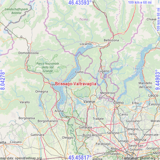
Brissago-Valtravaglia GPS coordinates[2]
45° 56' 57.156" North, 8° 44' 45.24" East
| Map corner | latitude | longitude |
|---|---|---|
| Upper-left | 46.43593°, | 8.04278° |
| Center: | 45.94921°, | 8.7459° |
| Lower-right: | 45.45817°, | 9.44903° |
| Map W x H: | 108.7×108.7 km | = 67.5×67.5mi |
| max Lat: | 47.04031° ⇑9.4% North |
| Brissago-Valtravaglia: | 45.94921° |
| min Lat: | ⇓90.6% South 35.50142° |
| min Long | Brissago-Valtra | max Long |
| 6.69888° | 8.7459° | 18.48682° |
| W 15.1%⇐ | ⇒84.9% E |
Elevation
Elevation of Brissago-Valtravaglia is 425 m = 1394 ft, and this is 118.3 m = 388 ft above average elevation for this country.
| Max E: |
2085 m = 6841 ft | 27% |
| Brissago-Valtravaglia | 425 m 1394 ft | |
| Avg. | 306.7 m = 1006 ft | |
Min E: |
-4 m = -13 ft | 73% |
See also: Italy elevation on elevation.city.
Geographical zone
Brissago-Valtravaglia is located in North temperate zone (between Tropic of Cancer and the Arctic Circle). Distance of this North polar circle is 2292.1 km =1424.2 mi to North.| Distance of | km | miles | from Brissago-Valtravaglia |
|---|---|---|---|
| North Pole | 4898 | 3043.5 | to North |
| Arctic Circle | 2292.1 | 1424.2 | to North |
| Tropic Cancer | 2503.2 | 1555.4 | to South |
| Equator | 5109.1 | 3174.6 | to South |


Nearby cities:
15 places around Brissago-Valtravaglia: (largest is in red/bold)
• Bedero
3.8 km =2.4 mi,  326°
326°
• Brezzo di Bedero
3.9 km =2.4 mi, 325°
• Cassano Valcuvia
2.6 km =1.6 mi,  137°
137°
• Cunardo
5.1 km =3.2 mi,  109°
109°
• Cuveglio
4.9 km =3 mi,  191°
191°
• Duno
4 km =2.5 mi, 189°
• Ferrera di Varese
3.8 km =2.4 mi,  118°
118°
• Germignaga
5 km =3.1 mi,  340°
340°
• Grantola
2.2 km =1.4 mi,  90°
90°
• Masciago Primo
4.4 km =2.7 mi, 142°
• Mesenzana
1.5 km =0.9 mi,  79°
79°
• Montegrino Valtravaglia
3.2 km =2 mi,  31°
31°
• Piano
1.7 km =1.1 mi,  18°
18°
• Porto Valtravaglia
5.2 km =3.2 mi,  284°
284°
• Rancio Valcuvia
4.2 km =2.6 mi,  151°
151°
Sources, notices
• [Note1] Compared only with cities in Italy existing in our database
• [Src1] Map data: © OpenStreetMap contributors (CC-BY-SA)
• [Src2] Other city data from geonames.org with taken over terms of usage.
• [Src3] Geographical zone / Annual Mean Temperature by Robert A. Rohde @ Wikipedia
